
Size of this preview: 537 × 600 pixels. Other resolutions: 215 × 240 pixels | 430 × 480 pixels | 862 × 963 pixels.
Original file (862 × 963 pixels, file size: 516 KB, MIME type: image/jpeg)
| This is a file from the Wikimedia Commons. Information from its description page there is shown below. Commons is a freely licensed media file repository. You can help. |
Summary
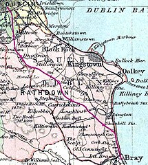
Philips' Handy Atlas of the Counties of Ireland (extract). John Bartholemew, F.R.G.S., published by George Philip & Son, London (1887)
Licensing
|
This work is in the public domain in its country of origin and other countries and areas where the copyright term is the author's life plus 100 years or fewer. | |
| This file has been identified as being free of known restrictions under copyright law, including all related and neighboring rights. | |
File history
Click on a date/time to view the file as it appeared at that time.
| Date/Time | Thumbnail | Dimensions | User | Comment | |
|---|---|---|---|---|---|
| current | 21:58, 21 May 2008 | | 862 × 963 (516 KB) | Suckindiesel | Philips' Handy Atlas of the Counties of Ireland (extract). John Bartholemew, F.R.G.S., published by George Philip & Son, London (1887) == Licensing == {{PD-old}} |
File usage
The following pages on the English Wikipedia use this file (pages on other projects are not listed):