.jpg)
.jpg&action=edit&redlink=1)
Original file (1,024 × 830 pixels, file size: 558 KB, MIME type: image/jpeg)
| This is a file from the Wikimedia Commons. Information from its description page there is shown below. Commons is a freely licensed media file repository. You can help. |
.jpg)
Summary
| Description |
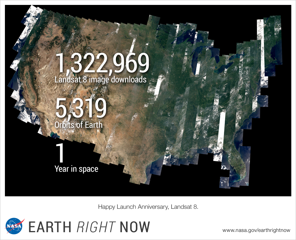
This image shows one of the first complete views of the contiguous United States captured by the Landsat 8 satellite. On Feb. 11, 2013, NASA launched Landsat 8 from Vandenberg Air Force Base in California and 100 days later transferred operational control to the U.S. Geological Survey. Landsat 8 then joined its predecessor satellites in providing a continuous record of change across Earth's land surfaces since 1972. Producing one of the longest-running satellite data sets of any kind, the Landsat program gives scientists around the world an invaluable benchmark to document and study our changing planet. Landsat satellites observe natural processes such as volcanic eruptions, glacial retreat, floods, and forest fires, as well as human-induced processes such as urban expansion, crop irrigation, and forest clear-cutting. To learn more about how this image was produced, go to: earthobservatory.nasa.gov/IOTD/view.php?id=83099 To learn more about Landsat 8, go to: www.nasa.gov/content/goddard/nasa-usgs-landsat-8-satellit... To learn more about NASA's plans to study Earth in 2014, go to: www.nasa.gov/earthrightnow NASA Goddard Space Flight Center enables NASA’s mission through four scientific endeavors: Earth Science, Heliophysics, Solar System Exploration, and Astrophysics. Goddard plays a leading role in NASA’s accomplishments by contributing compelling scientific knowledge to advance the Agency’s mission. Follow us on Twitter Like us on Facebook Find us on Instagram |
| Date | |
| Source | Happy Launch Anniversary, Landsat 8 |
| Author | NASA Goddard Space Flight Center from Greenbelt, MD, USA |
Licensing
- You are free:
- to share – to copy, distribute and transmit the work
- to remix – to adapt the work
- Under the following conditions:
- attribution – You must give appropriate credit, provide a link to the license, and indicate if changes were made. You may do so in any reasonable manner, but not in any way that suggests the licensor endorses you or your use.
| This image was originally posted to Flickr by NASA Goddard Photo and Video at https://flickr.com/photos/24662369@N07/12463694884. It was reviewed on 17 September 2016 by FlickreviewR and was confirmed to be licensed under the terms of the cc-by-2.0. |
| This file is in the public domain in the United States because it was solely created by NASA. NASA copyright policy states that "NASA material is not protected by copyright unless noted". (See Template:PD-USGov, NASA copyright policy page or JPL Image Use Policy.) | ||
 |
Warnings:
|
File history
Click on a date/time to view the file as it appeared at that time.
| Date/Time | Thumbnail | Dimensions | User | Comment | |
|---|---|---|---|---|---|
| current | 20:45, 17 September 2016 | | 1,024 × 830 (558 KB) | Vanished Account Byeznhpyxeuztibuo | Transferred from Flickr via Flickr2Commons |
File usage
Global file usage
The following other wikis use this file:
- Usage on tr.wikipedia.org
.jpg)