Size of this preview: 409 × 599 pixels. Other resolutions: 164 × 240 pixels | 437 × 640 pixels.
Original file (437 × 640 pixels, file size: 114 KB, MIME type: image/jpeg)
| This is a file from the Wikimedia Commons. Information from its description page there is shown below. Commons is a freely licensed media file repository. You can help. |
Summary
| Description |
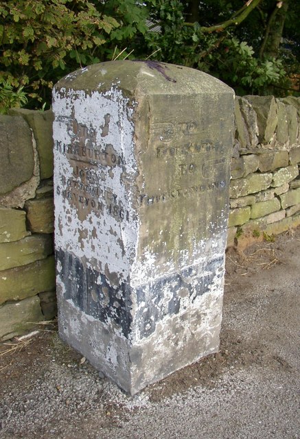
English: Guide stone, Thurstonland Road, Farnley Tyas This gives the directions to Kirkburton, with the surveyor's name, John Bottomley, and the year 1861. On the other face it is left to Farnley and right to Thurstonland. |
| Date | |
| Source | From geograph.org.uk |
| Author | Humphrey Bolton |
| Attribution (required by the license) | Humphrey Bolton / Guide stone, Thurstonland Road, Farnley Tyas / |
| Camera location | | View this and other nearby images on: OpenStreetMap |
|---|
_heading:90.00&language=en)
| Object location | | View this and other nearby images on: OpenStreetMap |
|---|
_heading:90.00&language=en)
Licensing

|
This image was taken from the Geograph project collection. See this photograph's page on the Geograph website for the photographer's contact details. The copyright on this image is owned by Humphrey Bolton and is licensed for reuse under the Creative Commons Attribution-ShareAlike 2.0 license.
|
This file is licensed under the Creative Commons Attribution-Share Alike 2.0 Generic license.
Attribution: Humphrey Bolton
- You are free:
- to share – to copy, distribute and transmit the work
- to remix – to adapt the work
- Under the following conditions:
- attribution – You must give appropriate credit, provide a link to the license, and indicate if changes were made. You may do so in any reasonable manner, but not in any way that suggests the licensor endorses you or your use.
- share alike – If you remix, transform, or build upon the material, you must distribute your contributions under the same or compatible license as the original.
File history
Click on a date/time to view the file as it appeared at that time.
| Date/Time | Thumbnail | Dimensions | User | Comment | |
|---|---|---|---|---|---|
| current | 03:05, 6 February 2011 | | 437 × 640 (114 KB) | GeographBot | == {{int:filedesc}} == {{Information |description={{en|1=Guide stone, Thurstonland Road, Farnley Tyas This gives the directions to Kirkburton, with the surveyor's name, John Bottomley, and the year 1861. On the other face it is left to Farnley and right |
File usage
The following pages on the English Wikipedia use this file (pages on other projects are not listed):