
Size of this preview: 800 × 533 pixels. Other resolutions: 320 × 213 pixels | 640 × 427 pixels | 1,024 × 683 pixels | 1,280 × 853 pixels | 2,560 × 1,706 pixels | 4,301 × 2,867 pixels.
Original file (4,301 × 2,867 pixels, file size: 12.16 MB, MIME type: image/jpeg)
| This is a file from the Wikimedia Commons. Information from its description page there is shown below. Commons is a freely licensed media file repository. You can help. |
Summary
| Description |
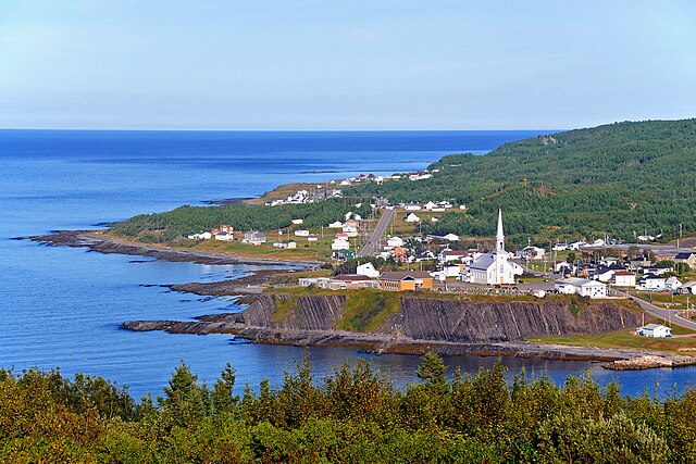
English: Grande-Vallée is a village situated halfway between Sainte-Anne-des-Monts and Gaspé, on the northern shore of the Gaspésie peninsula. It is one of the four villages forming the sector commonly known as « l'Estran ».
It owes its name to the passing of an immense glacier many thousands of years ago. This glacier's passage left an indelible mark, in the form of a valley, amongst the robust Appalachian Mountains. Here, the mountains literally embrace the sea while the river marries its waters with her own.
Français : Grande-Vallée est un village situé à mi-chemin entre Sainte-Anne-des-Monts et Gaspé, sur la côte nord de la péninsule de la Gaspésie.Il fait partie d'un petit groupe de quatre villages constituant un secteur surnommé l'Estran.
Il doit son nom à la vallée creusée il y a des milliers d'années par le passage d'un immense glacier en travers de la chaîne de montagnes des Appalaches. En ces lieux les montagnes embrassent la mer alors que la rivière y marie ses eaux. |
| Date | |
| Source |
|
| Author | Dennis Jarvis from Halifax, Canada |
| Camera location | | View this and other nearby images on: OpenStreetMap |
|---|
Licensing
This file is licensed under the Creative Commons Attribution-Share Alike 2.0 Generic license.
- You are free:
- to share – to copy, distribute and transmit the work
- to remix – to adapt the work
- Under the following conditions:
- attribution – You must give appropriate credit, provide a link to the license, and indicate if changes were made. You may do so in any reasonable manner, but not in any way that suggests the licensor endorses you or your use.
- share alike – If you remix, transform, or build upon the material, you must distribute your contributions under the same or compatible license as the original.
| This image, originally posted to Flickr, was reviewed on March 13, 2012 by the administrator or reviewer File Upload Bot (Magnus Manske), who confirmed that it was available on Flickr under the stated license on that date. |
File history
Click on a date/time to view the file as it appeared at that time.
| Date/Time | Thumbnail | Dimensions | User | Comment | |
|---|---|---|---|---|---|
| current | 12:43, 13 March 2012 | | 4,301 × 2,867 (12.16 MB) | File Upload Bot (Magnus Manske) | {{Information |Description=PLEASE, no multi invitations in your comments. DO NOT FEEL YOU HAVE TO COMMENT.Thanks. DO NOT SEND ME E-MAIL REQUESTING ME TO LOOK AT A PICTURE, I RETURN ALL COMMENTS IF YOU COMMENT. This is where I stopped for the night, ar... |
File usage
The following pages on the English Wikipedia use this file (pages on other projects are not listed):
Global file usage
The following other wikis use this file:
- Usage on ar.wikipedia.org
- Usage on arz.wikipedia.org
- Usage on atj.wikipedia.org
- Usage on eu.wikipedia.org
- Usage on fr.wikipedia.org
- Usage on fr.wikivoyage.org
- Usage on it.wikipedia.org
- Usage on ru.wikivoyage.org
- Usage on sv.wikipedia.org
- Usage on www.wikidata.org