
Size of this preview: 488 × 599 pixels. Other resolutions: 195 × 240 pixels | 391 × 480 pixels | 974 × 1,196 pixels.
Original file (974 × 1,196 pixels, file size: 246 KB, MIME type: image/jpeg)
| This is a file from the Wikimedia Commons. Information from its description page there is shown below. Commons is a freely licensed media file repository. You can help. |
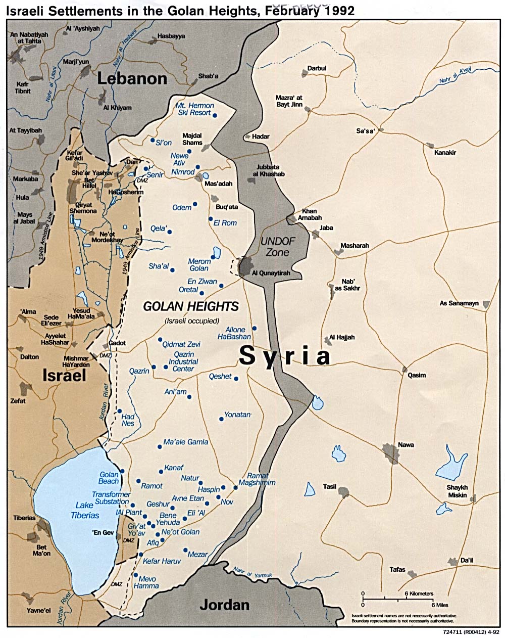
source: http://de.wikipedia.org/wiki/Bild:GolanHights.JPG
Summary
Die Golanhöhen damals und heute, nach den Eroberungen von 1967 und 1973.
Als Basis diente folgende Karte, die sich laut en.wiki unter public domain befindet.
Licensing
I, the copyright holder of this work, hereby publish it under the following license:

|
Permission is granted to copy, distribute and/or modify this document under the terms of the GNU Free Documentation License, Version 1.2 or any later version published by the Free Software Foundation; with no Invariant Sections, no Front-Cover Texts, and no Back-Cover Texts. A copy of the license is included in the section entitled GNU Free Documentation License. |
| This file is licensed under the Creative Commons Attribution-Share Alike 3.0 Unported license. | ||
| ||
| This licensing tag was added to this file as part of the GFDL licensing update. |
22 Jan 2006
de:Benutzer:Hoheit
File history
Click on a date/time to view the file as it appeared at that time.
| Date/Time | Thumbnail | Dimensions | User | Comment | |
|---|---|---|---|---|---|
| current | 14:56, 10 May 2008 | | 974 × 1,196 (246 KB) | Ori~ | |
| 14:55, 10 May 2008 |  | 980 × 1,282 (240 KB) | Ori~ | source: http://de.wikipedia.org/wiki/Bild:GolanHights.JPG == Beschreibung, Quelle == Die Golanhöhen damals und heute, nach den Eroberungen von 1967 und 1973. Als Basis diente folgende [http://www.lib.utexas.edu/maps/middle_east_and_asia/golan_92.jpg Ka |
File usage
The following pages on the English Wikipedia use this file (pages on other projects are not listed):
Global file usage
The following other wikis use this file:
- Usage on ar.wikipedia.org
- Usage on ca.wikipedia.org
- Resolució 350 del Consell de Seguretat de les Nacions Unides
- Resolució 363 del Consell de Seguretat de les Nacions Unides
- Resolució 557 del Consell de Seguretat de les Nacions Unides
- Resolució 695 del Consell de Seguretat de les Nacions Unides
- Resolució 722 del Consell de Seguretat de les Nacions Unides
- Resolució 996 del Consell de Seguretat de les Nacions Unides
- Resolució 1211 del Consell de Seguretat de les Nacions Unides
- Resolució 1788 del Consell de Seguretat de les Nacions Unides
- Resolució 1994 del Consell de Seguretat de les Nacions Unides
- Resolució 2294 del Consell de Seguretat de les Nacions Unides
- Usage on ckb.wikipedia.org
- Usage on cs.wikipedia.org
- Usage on es.wikipedia.org
- Usage on fa.wikipedia.org
- Usage on he.wikipedia.org
- Usage on id.wikipedia.org
- Usage on mzn.wikipedia.org
- Usage on nl.wikipedia.org
- Usage on tg.wikipedia.org
- Usage on www.wikidata.org