.jpg)
.jpg&action=edit&redlink=1)

Size of this preview: 597 × 600 pixels. Other resolutions: 239 × 240 pixels | 478 × 480 pixels | 765 × 768 pixels | 1,019 × 1,024 pixels | 2,039 × 2,048 pixels | 3,386 × 3,401 pixels.
Original file (3,386 × 3,401 pixels, file size: 1.13 MB, MIME type: image/jpeg)
| This is a file from the Wikimedia Commons. Information from its description page there is shown below. Commons is a freely licensed media file repository. You can help. |
.jpg)
Summary
| Description |
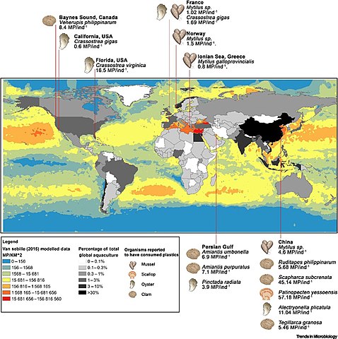
English: Global microplastic abundance at the ocean surface (ArcGIS) Modelled Sea-surface Microplastic Abundances (Particles km-2) Using Data from the Van Sebille Model (2015) with the Abundances Plotted on a Log Scale (Blue = Low, Red = High). |
| Date | |
| Source | [1] doi:10.1016/j.tim.2020.06.011 |
| Author |
Jake Bowley, Craig Baker-Austin, Adam Porter, Rachel Hartnell and Ceri Lewis |
Licensing
This file is licensed under the Creative Commons Attribution-Share Alike 4.0 International license.
- You are free:
- to share – to copy, distribute and transmit the work
- to remix – to adapt the work
- Under the following conditions:
- attribution – You must give appropriate credit, provide a link to the license, and indicate if changes were made. You may do so in any reasonable manner, but not in any way that suggests the licensor endorses you or your use.
- share alike – If you remix, transform, or build upon the material, you must distribute your contributions under the same or compatible license as the original.
File history
Click on a date/time to view the file as it appeared at that time.
| Date/Time | Thumbnail | Dimensions | User | Comment | |
|---|---|---|---|---|---|
| current | 21:39, 14 September 2021 | | 3,386 × 3,401 (1.13 MB) | Epipelagic | Uploaded a work by Jake Bowley, Craig Baker-Austin, Adam Porter, Rachel Hartnell and Ceri Lewis<br /> ArcGIS version 10.6.1 from [https://www.cell.com/trends/microbiology/fulltext/S0966-842X(20)30190-6] {{doi|10.1016/j.tim.2020.06.011}} with UploadWizard |
File usage
The following pages on the English Wikipedia use this file (pages on other projects are not listed):
Global file usage
The following other wikis use this file:
- Usage on af.wikipedia.org
- Usage on fr.wikipedia.org
.jpg)