
Size of this preview: 755 × 600 pixels. Other resolutions: 302 × 240 pixels | 604 × 480 pixels | 1,013 × 805 pixels.
Original file (1,013 × 805 pixels, file size: 732 KB, MIME type: image/png)
| This is a file from the Wikimedia Commons. Information from its description page there is shown below. Commons is a freely licensed media file repository. You can help. |
Summary
| Description |
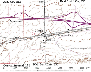
English: Topographic map of Glenrio, (New Mexico, Texas) showing about a mile N-S and 1.5 miles E-W, including Interstate 40. The state and county designations have been added to the USGS base, as well as labeling Interstate 40. |
| Date | 1982, modified 13 November 2008 by uploader to add labels |
| Source | USGS 1:24000 quddrangle, Glenrio, N. Mex. - Tex., N3507.5-W10300/7.5 (1968, photorevised 1982) DMA 5354 II NE - Series V881 |
| Author | United States Geological Survey (USGS), modified by Bejnar |
| Permission (Reusing this file) |
public domain |
Licensing
This image is in the public domain in the United States because it only contains materials that originally came from the United States Geological Survey, an agency of the United States Department of the Interior. For more information, see the official USGS copyright policy.
|
File history
Click on a date/time to view the file as it appeared at that time.
| Date/Time | Thumbnail | Dimensions | User | Comment | |
|---|---|---|---|---|---|
| current | 18:41, 13 November 2008 | | 1,013 × 805 (732 KB) | Bejnar | {{Information |Description={{en|1=Topographic map of Glenrio, (New Mexico, Texas) showing about a mile N-S and 1.5 miles E-W, including Interstate 40. The state and county designations have been added to the USGS base, as well as labeling Interstate 40.} |
File usage
The following pages on the English Wikipedia use this file (pages on other projects are not listed):
Global file usage
The following other wikis use this file: