Germany_and_Poland_borders_during_the_20th_century.gif (500 × 320 pixels, file size: 6 KB, MIME type: image/gif)
Summary edit
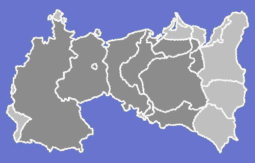
Anachronical map of Germany and Poland border changes during the 20th century.
The borders represent:
Until World War I:
After World War I until Anschluss:
After World War II until the Revolutions of 1989:
After the end of the Soviet Union:
I made this map on a Beige G3 running Photoshop using these maps as reference:
Licensing: edit
 | Permission is granted to copy, distribute and/or modify this document under the terms of the GNU Free Documentation License, Version 1.2 or any later version published by the Free Software Foundation; with no Invariant Sections, no Front-Cover Texts, and no Back-Cover Texts. |
| This work is licensed under the Creative Commons Attribution-ShareAlike 3.0 License. This licensing tag was added to this file as part of the GFDL licensing update. |
Other versions edit
A flag-coloured one… is here, at Wikimedia Commons.
_and_their_different_borders_during_the_20th_century.gif)
 | This file is a candidate to be copied to Wikimedia Commons.
Any user may perform this transfer; refer to Wikipedia:Moving files to Commons for details. If this file has problems with attribution, copyright, or is otherwise ineligible for Commons, then remove this tag and DO NOT transfer it; repeat violators may be blocked from editing. Other Instructions
| ||
| |||
File history
Click on a date/time to view the file as it appeared at that time.
| Date/Time | Thumbnail | Dimensions | User | Comment | |
|---|---|---|---|---|---|
| current | 00:48, 15 August 2008 | | 500 × 320 (6 KB) | MaGioZal (talk | contribs) | Anachronical map pf Germany and Poland border changes during the 20th century. I made this map usaing these maps as reference: KingdomofPoland1815.jpg [[:Image:Österreich-Ungarns Ende.png|Österreich-Ungar |
You cannot overwrite this file.
File usage
- Talk:West Germany/Archive 1
- Wikipedia talk:German-speaking Wikipedians' notice board/Archive 6
- Template:Germany and Poland Border Changes 20th century
- Template talk:Territorial evolution of Germany
- Template talk:Territorial evolution of Poland
- Portal talk:Poland/Poland-related Wikipedia notice board/Archive 11