No higher resolution available.
Gatehouse_arch_to_Columb_John_mansion_house,_c.1590.jpg (640 × 480 pixels, file size: 88 KB, MIME type: image/jpeg)
| This is a file from the Wikimedia Commons. Information from its description page there is shown below. Commons is a freely licensed media file repository. You can help. |
This is a photo of listed building number 1170597. |
Summary
| Description |
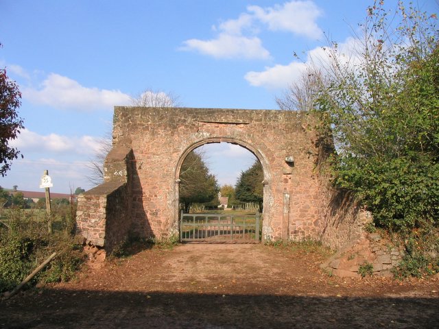
English: Archway, circa 1590, of the former gatehouse of the demolished Acland family mansion house of Columb John in the parish of Broadclyst, Devon. The house was abandoned by the Aclands who moved to adjacent Killerton House. At the start of the footpath leading to the woods adjoining Killerton woods. In the distance is visible St John's Chapel, built in 1851 by a member of the Acland family on the site of an ancient private chapel of the mansion house of Columb John. (Pevsner, Nikolaus & Cherry, Bridget, The Buildings of England: Devon, London, 2004, p.279) |
| Date | |
| Source | From geograph.org.uk |
| Author | john spivey |
| Attribution (required by the license) | john spivey / Old farm entrance at Columbjohn / |
| Object location | | View this and other nearby images on: OpenStreetMap |
|---|
_&language=en)
Licensing

|
This image was taken from the Geograph project collection. See this photograph's page on the Geograph website for the photographer's contact details. The copyright on this image is owned by john spivey and is licensed for reuse under the Creative Commons Attribution-ShareAlike 2.0 license.
|
This file is licensed under the Creative Commons Attribution-Share Alike 2.0 Generic license.
Attribution: john spivey
- You are free:
- to share – to copy, distribute and transmit the work
- to remix – to adapt the work
- Under the following conditions:
- attribution – You must give appropriate credit, provide a link to the license, and indicate if changes were made. You may do so in any reasonable manner, but not in any way that suggests the licensor endorses you or your use.
- share alike – If you remix, transform, or build upon the material, you must distribute your contributions under the same or compatible license as the original.
File history
Click on a date/time to view the file as it appeared at that time.
| Date/Time | Thumbnail | Dimensions | User | Comment | |
|---|---|---|---|---|---|
| current | 15:57, 30 January 2010 | | 640 × 480 (88 KB) | GeographBot | == {{int:filedesc}} == {{Information |description={{en|1=Old farm entrance at Columbjohn. The start of the footpath leading to the woods adjoining Killerton woods.}} |date=2003-10-23 |source=From [http://www.geograph.org.uk/photo/31162 geograph.org.uk] |a |
File usage
The following pages on the English Wikipedia use this file (pages on other projects are not listed):
Global file usage
The following other wikis use this file:
- Usage on www.wikidata.org