
Size of this preview: 800 × 600 pixels. Other resolutions: 320 × 240 pixels | 640 × 480 pixels | 1,024 × 768 pixels | 1,280 × 960 pixels | 2,560 × 1,920 pixels | 2,816 × 2,112 pixels.
Original file (2,816 × 2,112 pixels, file size: 2.87 MB, MIME type: image/jpeg)
| This is a file from the Wikimedia Commons. Information from its description page there is shown below. Commons is a freely licensed media file repository. You can help. |
|
This is an image of a place or building that is listed on the National Register of Historic Places in the United States of America. Its reference number is 79000021. |
| Camera location | | View this and other nearby images on: OpenStreetMap |
|---|
| Description |
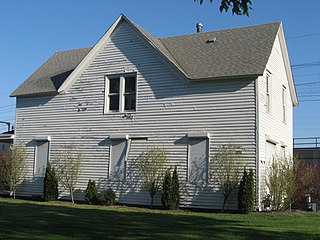
English: Front and eastern side of the Gary Land Company Building, located at the intersection of Fourth Avenue (U.S. Routes 12/20) and Massachusetts Street in Gary, Indiana, United States. Built in 1906 as the first building in Gary, it has functioned as a city hall, post office, school, and business building. It is listed on the National Register of Historic Places. |
||
| Date | Taken on 12 April 2012 | ||
| Source | Own work | ||
| Author | Nyttend | ||
| Permission (Reusing this file) |
|
File history
Click on a date/time to view the file as it appeared at that time.
| Date/Time | Thumbnail | Dimensions | User | Comment | |
|---|---|---|---|---|---|
| current | 16:31, 7 May 2012 | | 2,816 × 2,112 (2.87 MB) | Nyttend | {{NRHP|79000021}} {{Location|41|36|15|N|87|20|9|W}} {{Information |Description={{en|Front and eastern side of the {{w|Gary Land Company Building}}, located at the intersection of Fourth Avenue (U.S. Routes {{w|U.S. Route 12|12}}/{{w|U.S. Route 20|20}})... |
File usage
The following pages on the English Wikipedia use this file (pages on other projects are not listed):
Global file usage
The following other wikis use this file:
- Usage on de.wikipedia.org
- Usage on fa.wikipedia.org
- Usage on www.wikidata.org