Size of this preview: 345 × 599 pixels. Other resolutions: 138 × 240 pixels | 570 × 989 pixels.
Original file (570 × 989 pixels, file size: 144 KB, MIME type: image/png)
| This is a file from the Wikimedia Commons. Information from its description page there is shown below. Commons is a freely licensed media file repository. You can help. |
Summary
| Description |
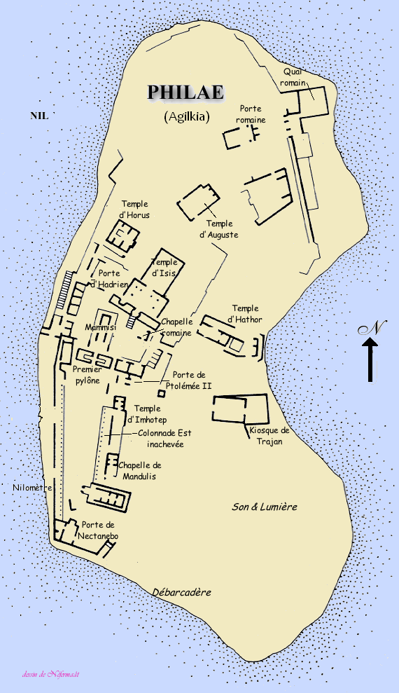
English: Island of Agilkia. In the 1960s, every building was dismantled, and transported to the nearby island of Agilkia, situated on higher ground some 500 m away.
Français : Plan de Agilkia, (Égypte). |
| Date | |
| Source | Own work |
| Author | Gérard Ducher(Néfermaât) |
Licensing
This file is licensed under the Creative Commons Attribution-Share Alike 2.5 Generic license.
- You are free:
- to share – to copy, distribute and transmit the work
- to remix – to adapt the work
- Under the following conditions:
- attribution – You must give appropriate credit, provide a link to the license, and indicate if changes were made. You may do so in any reasonable manner, but not in any way that suggests the licensor endorses you or your use.
- share alike – If you remix, transform, or build upon the material, you must distribute your contributions under the same or compatible license as the original.
Source
Français : Dessin de Gérard Ducher (user:Néfermaât).
English: Drawing by Gérard Ducher
File history
Click on a date/time to view the file as it appeared at that time.
| Date/Time | Thumbnail | Dimensions | User | Comment | |
|---|---|---|---|---|---|
| current | 11:03, 20 June 2011 | | 570 × 989 (144 KB) | JMCC1 | Agilkia text |
| 17:26, 8 January 2006 |  | 570 × 989 (150 KB) | Néfermaât | == Description == fr: Plan de Philaé Égypte. ==Source== fr: Dessin de Gérard Ducher (user:Néfermaât). Nefermaat == Licence == {{cc-by-sa-2.5}} |
File usage
The following pages on the English Wikipedia use this file (pages on other projects are not listed):
Global file usage
The following other wikis use this file:
- Usage on ar.wikipedia.org
- Usage on cs.wikipedia.org
- Usage on de.wikipedia.org
- Usage on es.wikipedia.org
- Usage on fr.wikipedia.org
- Usage on gl.wikipedia.org
- Usage on hr.wikipedia.org
- Usage on ms.wikipedia.org
- Usage on nl.wikipedia.org
- Usage on oc.wikipedia.org
- Usage on sh.wikipedia.org
- Usage on vi.wikipedia.org