
Size of this preview: 551 × 600 pixels. Other resolutions: 220 × 240 pixels | 441 × 480 pixels | 705 × 768 pixels | 941 × 1,024 pixels | 2,401 × 2,614 pixels.
Original file (2,401 × 2,614 pixels, file size: 3.03 MB, MIME type: image/png)
| This is a file from the Wikimedia Commons. Information from its description page there is shown below. Commons is a freely licensed media file repository. You can help. |
Summary
| Description |
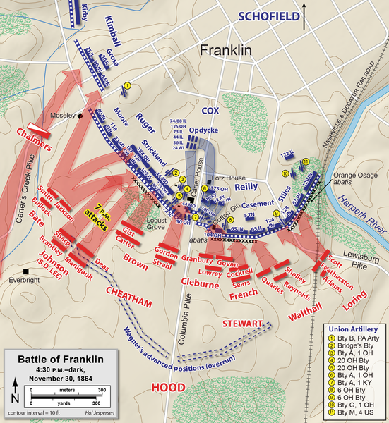
English: Map of the Battle of Franklin of the American Civil War, showing the Union defensive lines at 4:30 PM. Drawn in Adobe Illustrator CC by Hal Jespersen. Graphic source file is available at https://www.cwmaps.com/freemaps.html |
| Date | |
| Source | Own work |
| Author | Hal Jespersen at en.wikipedia |
Licensing
Hal Jespersen at en.wikipedia, the copyright holder of this work, hereby publishes it under the following license:
This file is licensed under the Creative Commons Attribution 3.0 Unported license.
Attribution: Map by Hal Jespersen, www.cwmaps.com
- You are free:
- to share – to copy, distribute and transmit the work
- to remix – to adapt the work
- Under the following conditions:
- attribution – You must give appropriate credit, provide a link to the license, and indicate if changes were made. You may do so in any reasonable manner, but not in any way that suggests the licensor endorses you or your use.
Original upload log
The original description page was here. All following user names refer to en.wikipedia.
- 2010-01-15 22:48 Hlj 1911×1127× (383472 bytes) Minor corrections to west end of line. {{cc-by-3.0|Map by Hal Jespersen, www.posix.com/CW}}
- 2010-01-06 23:46 Hlj 1911×1127× (383157 bytes) Corrected Union positions east of the Columbia Pike. {{cc-by-3.0|Map by Hal Jespersen, www.posix.com/CW}}
- 2010-01-03 00:10 Hlj 1911×1127× (362145 bytes) {{Information |Description=Map of the [[Battle of Franklin]] of the [[American Civil War]], showing the Union defensive lines at 4:30 PM. Drawn in Adobe Illustrator CS3 by Hal Jespersen. Graphic source file is available at http://www.posix.com/CWmaps/ |So
File history
Click on a date/time to view the file as it appeared at that time.
| Date/Time | Thumbnail | Dimensions | User | Comment | |
|---|---|---|---|---|---|
| current | 19:02, 15 February 2021 | | 2,401 × 2,614 (3.03 MB) | Hlj | improve background accuracy of my previous map |
| 19:23, 19 December 2013 |  | 3,849 × 2,256 (1.31 MB) | Hlj | Corrected brigade alignment in Loring's division. Cleaned up some attack arrows. Same license. | |
| 18:00, 16 March 2011 |  | 1,924 × 1,128 (583 KB) | Hlj | Improve the accuracy of Union retreats and counterattacks. Minor graphical changes to adopt new style of roads and water. Same license. | |
| 15:02, 13 November 2010 |  | 1,924 × 1,128 (560 KB) | Hlj | Oops, correct the date again. | |
| 15:00, 13 November 2010 |  | 1,924 × 1,128 (560 KB) | Hlj | Corrected date in legend. Same license. | |
| 00:46, 15 February 2010 |  | 1,911 × 1,127 (544 KB) | Hlj | Update to include brigade and division commander, Confederate attacks. Same license. | |
| 15:15, 24 January 2010 |  | 1,911 × 1,127 (374 KB) | BotMultichill | {{BotMoveToCommons|en.wikipedia|year={{subst:CURRENTYEAR}}|month={{subst:CURRENTMONTHNAME}}|day={{subst:CURRENTDAY}}}} {{Information |Description={{en|Map of the en:Battle of Franklin of the en:American Civil War, showing the Union defensive |
File usage
The following pages on the English Wikipedia use this file (pages on other projects are not listed):
- 12th Louisiana Infantry Regiment (Confederate)
- 33rd Alabama Infantry Regiment
- 44th Missouri Infantry Regiment (Union)
- 65th Illinois Infantry Regiment
- 88th Illinois Infantry Regiment
- Battle of Franklin
- Bridges' Battery Illinois Light Artillery
- Franklin–Nashville campaign
- John S. Casement
- Patrick Cleburne
Global file usage
The following other wikis use this file:
- Usage on de.wikipedia.org
- Usage on es.wikipedia.org
- Usage on fr.wikipedia.org
- Usage on it.wikipedia.org
- Usage on nl.wikipedia.org