
Size of this preview: 495 × 599 pixels. Other resolutions: 198 × 240 pixels | 397 × 480 pixels | 1,015 × 1,228 pixels.
Original file (1,015 × 1,228 pixels, file size: 1.94 MB, MIME type: image/png)
| This is a file from the Wikimedia Commons. Information from its description page there is shown below. Commons is a freely licensed media file repository. You can help. |
Summary
| Description |
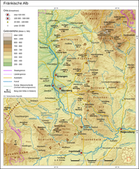
Deutsch: Fränkische Alb |
| Date | |
| Source |
Own work Map created using:
Several sources for watershed: |
| Author | Thoroe |
| Permission (Reusing this file) |
Map data (c) OpenStreetMap (and) contributors, CC-BY-SA |

|
This map has been made or improved in the German Kartenwerkstatt (Map Lab). You can propose maps to improve as well.
|
Licensing
This file is licensed under the Creative Commons Attribution-Share Alike 2.0 Generic license.
Attribution: Thomas Römer/OpenStreetMap data
- You are free:
- to share – to copy, distribute and transmit the work
- to remix – to adapt the work
- Under the following conditions:
- attribution – You must give appropriate credit, provide a link to the license, and indicate if changes were made. You may do so in any reasonable manner, but not in any way that suggests the licensor endorses you or your use.
- share alike – If you remix, transform, or build upon the material, you must distribute your contributions under the same or compatible license as the original.
File history
Click on a date/time to view the file as it appeared at that time.
| Date/Time | Thumbnail | Dimensions | User | Comment | |
|---|---|---|---|---|---|
| current | 06:46, 28 May 2014 | | 1,015 × 1,228 (1.94 MB) | Kopiersperre | optipng |
| 10:58, 26 October 2011 |  | 1,015 × 1,228 (2.18 MB) | Thoroe | +Itz +Rodach +Eger | |
| 16:24, 23 March 2011 |  | 1,015 × 1,228 (1.98 MB) | Thoroe | + einige Berge | |
| 11:58, 18 March 2011 |  | 1,015 × 1,229 (1.97 MB) | Thoroe | + einige Orte | |
| 14:16, 16 March 2011 |  | 1,015 × 1,228 (1.96 MB) | Thoroe | Wasserscheide etc. | |
| 23:19, 13 March 2011 |  | 1,015 × 1,228 (1.96 MB) | Thoroe | {{Information |Description ={{en|1=Franconian Jura, Germany}} {{de|1=Fränkische Alb}} |Source ={{own}} Map created using: *[http://gmt.soest.hawaii.edu Generic Mapping Tools (GMT |
File usage
The following pages on the English Wikipedia use this file (pages on other projects are not listed):
Global file usage
The following other wikis use this file:
- Usage on bg.wikipedia.org
- Usage on cs.wikipedia.org
- Usage on de.wikipedia.org
- Naab
- Fränkische Alb
- Vils (Naab)
- Hahnenkamm (Altmühltal)
- Liste von Bergen und Erhebungen der Fränkischen Alb
- Benutzer:Thoroe
- Wikipedia:Kartenwerkstatt/Archiv/2011-03
- Benutzer:Frze
- Naturräumliche Gliederung der Fränkischen Alb
- Wikipedia:Kartenwerkstatt/Karte des Tages/Galerie
- Geologie der Fränkischen Alb
- Fossilien der Fränkischen Alb
- Usage on eo.wikipedia.org
- Usage on es.wikipedia.org
- Usage on fr.wikipedia.org
- Usage on it.wikipedia.org
- Usage on nl.wikipedia.org
- Usage on no.wikipedia.org
- Usage on pl.wikipedia.org
- Usage on pl.wikivoyage.org
- Usage on vi.wikipedia.org
- Usage on www.wikidata.org