
Size of this preview: 800 × 478 pixels. Other resolutions: 320 × 191 pixels | 640 × 383 pixels | 1,024 × 612 pixels | 1,280 × 765 pixels | 2,392 × 1,430 pixels.
Original file (2,392 × 1,430 pixels, file size: 4.29 MB, MIME type: image/jpeg)
| This is a file from the Wikimedia Commons. Information from its description page there is shown below. Commons is a freely licensed media file repository. You can help. |
Summary
| Description |
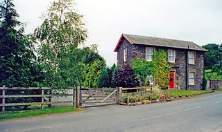
English: Fountainhall station (site/remains), 2000. View SE, towards Galashiels (and Tweedbank), Hawick and Carlisle, also Lauder: ex-NBR Waverley Route, Edinburgh - Hawick - Carlisle main Line, closed entirely 6/1/69. The station was entitled 'Fountainhall Junction' until 1959, because a branch used to go off to the left here to Lauder; this closed to passengers 12/9/32, to goods 1/10/58. Fountainhall is on the renewed Waverley Route, Edinburgh - Tweedbank, which in March 2014 is well advanced, but no new station is planned at this location. |
| Date | |
| Source | From geograph.org.uk |
| Author | Ben Brooksbank |
| Permission (Reusing this file) |
Creative Commons Attribution Share-alike license 2.0 |
| Attribution (required by the license) | Ben Brooksbank / Fountainhall station (site/remains), 2000 / |
| Camera location | | View this and other nearby images on: OpenStreetMap |
|---|
Licensing

|
This image was taken from the Geograph project collection. See this photograph's page on the Geograph website for the photographer's contact details. The copyright on this image is owned by Ben Brooksbank and is licensed for reuse under the Creative Commons Attribution-ShareAlike 2.0 license.
|
This file is licensed under the Creative Commons Attribution-Share Alike 2.0 Generic license.
Attribution: Ben Brooksbank
- You are free:
- to share – to copy, distribute and transmit the work
- to remix – to adapt the work
- Under the following conditions:
- attribution – You must give appropriate credit, provide a link to the license, and indicate if changes were made. You may do so in any reasonable manner, but not in any way that suggests the licensor endorses you or your use.
- share alike – If you remix, transform, or build upon the material, you must distribute your contributions under the same or compatible license as the original.
File history
Click on a date/time to view the file as it appeared at that time.
| Date/Time | Thumbnail | Dimensions | User | Comment | |
|---|---|---|---|---|---|
| current | 09:24, 29 March 2014 | | 2,392 × 1,430 (4.29 MB) | Chevin | == {{int:filedesc}} == {{Information |Description={{en|1='''Fountainhall station (site/remains), 2000.'''<br/> View SE, towards Galashiels (and Tweedbank), Hawick and Carlisle, also Lauder: ex-NBR Waverley Route, Edinburgh - Hawick - Carlisle main Line... |
File usage
The following pages on the English Wikipedia use this file (pages on other projects are not listed):
Global file usage
The following other wikis use this file:
- Usage on de.wikipedia.org
- Usage on www.wikidata.org