.jpg)
.jpg&action=edit&redlink=1)
Size of this preview: 800 × 572 pixels. Other resolutions: 320 × 229 pixels | 640 × 458 pixels | 900 × 644 pixels.
Original file (900 × 644 pixels, file size: 192 KB, MIME type: image/jpeg)
| This is a file from the Wikimedia Commons. Information from its description page there is shown below. Commons is a freely licensed media file repository. You can help. |
.jpg)
Summary
| Description |
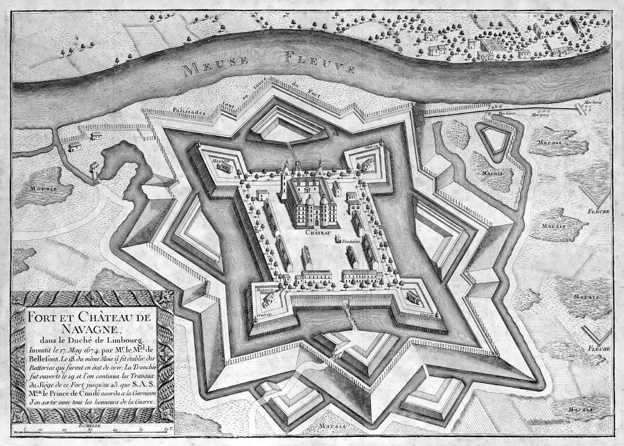
English: Map of the Fortress Navagne along the river Meuse near Moelingen, Belgium. The fortress was built by the Spanish in 1634-35 around the existing Castle of Navagne. The fortress was destroyed in 1674 by the French, rebuilt, and destroyed once more in 1702. Attributed to French cartographer Chevalier de Beaurain. Situation depicted as of 1674. |
| Date | between 1780 and 1782 |
| Source | http://www.breurhenket.com/Verraad.htm, (also Rijksmuseum FMH 2544) |
| Author | Attributed to French cartographer Chevalier de Beaurain |
| Object location | | View this and other nearby images on: OpenStreetMap |
|---|
.jpg¶ms=050.757006_N_0005.685436_E_globe:Earth_class:object_scale:6250_type:landmark_region:BE_&language=en)
Licensing
|
This is a faithful photographic reproduction of a two-dimensional, public domain work of art. The work of art itself is in the public domain for the following reason:
The official position taken by the Wikimedia Foundation is that "faithful reproductions of two-dimensional public domain works of art are public domain".
This photographic reproduction is therefore also considered to be in the public domain in the United States. In other jurisdictions, re-use of this content may be restricted; see Reuse of PD-Art photographs for details. | ||||
This work is in the public domain in the United States because it was published (or registered with the U.S. Copyright Office) before January 1, 1929.
Public domain works must be out of copyright in both the United States and in the source country of the work in order to be hosted on the Commons. If the work is not a U.S. work, the file must have an additional copyright tag indicating the copyright status in the source country.
Note: This tag should not be used for sound recordings. |
File history
Click on a date/time to view the file as it appeared at that time.
| Date/Time | Thumbnail | Dimensions | User | Comment | |
|---|---|---|---|---|---|
| current | 09:45, 16 January 2016 | | 900 × 644 (192 KB) | Kleon3 | User created page with UploadWizard |
File usage
The following pages on the English Wikipedia use this file (pages on other projects are not listed):
Global file usage
The following other wikis use this file:
- Usage on fr.wikipedia.org
- Usage on nl.wikipedia.org
.jpg)