
Size of this preview: 800 × 532 pixels. Other resolutions: 320 × 213 pixels | 640 × 426 pixels | 1,024 × 681 pixels | 1,280 × 851 pixels | 2,560 × 1,702 pixels | 6,016 × 4,000 pixels.
Original file (6,016 × 4,000 pixels, file size: 6.27 MB, MIME type: image/jpeg)
| This is a file from the Wikimedia Commons. Information from its description page there is shown below. Commons is a freely licensed media file repository. You can help. |
| Camera location | | View this and other nearby images on: OpenStreetMap |
|---|
| Description |
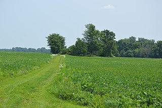
English: Fields in far southern Cessna Township, Hardin County, Ohio, United States. Dimly visible through the trees at the center of the image is the cemetery for Fort McArthur, a nearby War of 1812 installation; the men buried here died while stationed at the fort. |
||
| Date | Taken on 6 July 2015 | ||
| Source | Own work | ||
| Author | Nyttend | ||
| Permission (Reusing this file) |
|
File history
Click on a date/time to view the file as it appeared at that time.
| Date/Time | Thumbnail | Dimensions | User | Comment | |
|---|---|---|---|---|---|
| current | 01:52, 7 July 2015 | | 6,016 × 4,000 (6.27 MB) | Nyttend | {{Location|40|39|49|N|83|40|26|W}} {{Information |Description={{en|Fields in far southern {{w|Cessna Township, Hardin County, Ohio|Cessna Township}}, {{w|Hardin County, Ohio|Hardin County}}, {{w|Ohio}}, {{w|United States}}. Dimly visible through the t... |
File usage
The following pages on the English Wikipedia use this file (pages on other projects are not listed):
Global file usage
The following other wikis use this file:
- Usage on eu.wikipedia.org
- Usage on fa.wikipedia.org
- Usage on pt.wikipedia.org
- Usage on vi.wikipedia.org
- Usage on www.wikidata.org
- Usage on zh.wikipedia.org