No higher resolution available.
Fort_Clarence,_Rochester_-_geograph.org.uk_-_1067732.jpg (640 × 481 pixels, file size: 69 KB, MIME type: image/jpeg)
| This is a file from the Wikimedia Commons. Information from its description page there is shown below. Commons is a freely licensed media file repository. You can help. |
Summary
| Description |
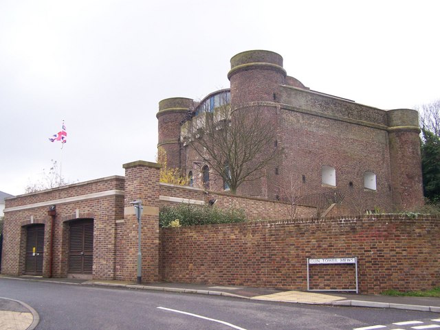
English: Fort Clarence, Rochester On junction of St Margarets Street and gun Tower Mews.
Former military fort. Was part of the Medway group of Forts (Fort Luton, Amherst, Borstal and Horsted). Now converted into a large private house. Very good conversion keeping most of the forts brickwork. Land to rear of fort now used by Rochester Territorial Army Centre. For more details on history see http://www.borstal.org.uk/history/fort_clarence.shtml |
| Date | |
| Source | From geograph.org.uk |
| Author | David Anstiss |
| Attribution (required by the license) | David Anstiss / Fort Clarence, Rochester / |
| Camera location | | View this and other nearby images on: OpenStreetMap |
|---|
_heading:157.00&language=en)
| Object location | | View this and other nearby images on: OpenStreetMap |
|---|
_heading:157.00&language=en)
Licensing

|
This image was taken from the Geograph project collection. See this photograph's page on the Geograph website for the photographer's contact details. The copyright on this image is owned by David Anstiss and is licensed for reuse under the Creative Commons Attribution-ShareAlike 2.0 license.
|
This file is licensed under the Creative Commons Attribution-Share Alike 2.0 Generic license.
Attribution: David Anstiss
- You are free:
- to share – to copy, distribute and transmit the work
- to remix – to adapt the work
- Under the following conditions:
- attribution – You must give appropriate credit, provide a link to the license, and indicate if changes were made. You may do so in any reasonable manner, but not in any way that suggests the licensor endorses you or your use.
- share alike – If you remix, transform, or build upon the material, you must distribute your contributions under the same or compatible license as the original.
File history
Click on a date/time to view the file as it appeared at that time.
| Date/Time | Thumbnail | Dimensions | User | Comment | |
|---|---|---|---|---|---|
| current | 04:05, 24 February 2011 | | 640 × 481 (69 KB) | GeographBot | == {{int:filedesc}} == {{Information |description={{en|1=Fort Clarence, Rochester On junction of St Margarets Street and gun Tower Mews. Former military fort. Was part of the Medway group of Forts (Fort Luton, Amherst, Borstal and Horsted). Now converted |
File usage
The following pages on the English Wikipedia use this file (pages on other projects are not listed):
Global file usage
The following other wikis use this file:
- Usage on www.wikidata.org