FortDavisCampaignMap.jpg (290 × 344 pixels, file size: 21 KB, MIME type: image/jpeg)
Summary edit
| Description |
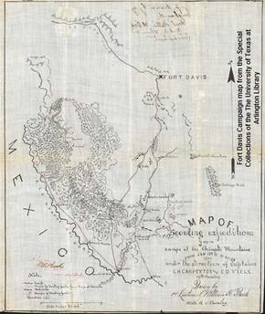
A photo of a black and white hand drawn map from 1880 showing Fort Davis and the Chinati Mountains used during military campaigns against the Apache Indians led by Victorio. |
|---|---|
| Source |
Special Collections, The University of Texas at Arlington Library |
| Article | |
| Portion used |
no |
| Low resolution? |
yes |
| Purpose of use |
For use in articles related to the description of the map. |
| Replaceable? |
Only known image of map partly commissioned by Louis H. Carpenter |
| Other information | |
| Fair useFair use of copyrighted material in the context of Louis H. Carpenter//en.wikipedia.org/wiki/File:FortDavisCampaignMap.jpgtrue | |
| Description |
A photo of a black and white hand drawn map from 1880 showing Fort Davis and the Chinati Mountains used during military campaigns against the Apache Indians led by Victorio. |
|---|---|
| Source |
Special Collections, The University of Texas at Arlington Library |
| Article | |
| Portion used |
no |
| Low resolution? |
yes |
| Purpose of use |
For use in articles related to the description of the map. |
| Replaceable? |
Only known image of map partly commissioned by Louis H. Carpenter |
| Other information | |
| Fair useFair use of copyrighted material in the context of Fort Davis National Historic Site//en.wikipedia.org/wiki/File:FortDavisCampaignMap.jpgtrue | |
| Description |
A photo of a black and white hand drawn map from 1880 showing Fort Davis and the Chinati Mountains used during military campaigns against the Apache Indians led by Victorio. |
|---|---|
| Source |
Special Collections, The University of Texas at Arlington Library |
| Article | |
| Portion used |
no |
| Low resolution? |
yes |
| Purpose of use |
For use in articles related to the description of the map. |
| Replaceable? |
Only known image of map partly commissioned by Louis H. Carpenter |
| Other information | |
| Fair useFair use of copyrighted material in the context of University of Texas at Arlington//en.wikipedia.org/wiki/File:FortDavisCampaignMap.jpgtrue | |
Licensing: edit
 | This image is a faithful digitisation of a unique historic image, and the copyright for it is most likely held by the person who created the image or the agency employing the person. It is believed that the use of this image may qualify as non-free use under the Copyright law of the United States. Any other uses of this image, on Wikipedia or elsewhere, may be copyright infringement. See Wikipedia:Non-free content for more information. Please remember that the non-free content criteria require that non-free images on Wikipedia must not "[be] used in a manner that is likely to replace the original market role of the original copyrighted media." Use of historic images from press agencies must only be of a transformative nature, when the image itself is the subject of commentary rather than the event it depicts (which is the original market role, and is not allowed per policy). |
| If this tag does not accurately describe this image, please replace it with an appropriate one. | |
File history
Click on a date/time to view the file as it appeared at that time.
| Date/Time | Thumbnail | Dimensions | User | Comment | |
|---|---|---|---|---|---|
| current | 02:40, 30 May 2017 | | 290 × 344 (21 KB) | DatBot (talk | contribs) | Reduce size of non-free image (BOT - disable) |
| 14:57, 26 August 2009 | No thumbnail | 475 × 564 (111 KB) | Jrcrin001 (talk | contribs) | {{Non-free use rationale |Article = Louis H. Carpenter |Description = A photo of a black and white hand drawn map from 1880 showing Fort Davis and the Chinati Mountains used during military campaigns against the Apache Indians led by Vic |
You cannot overwrite this file.