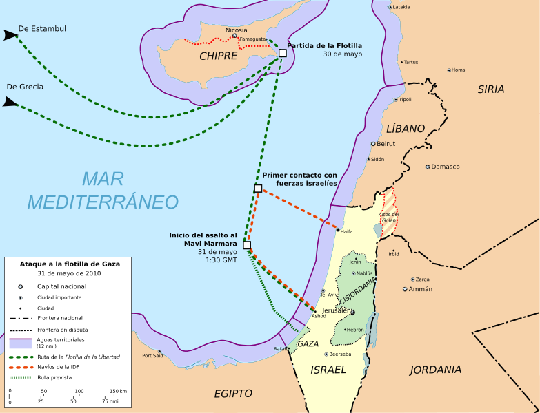
Size of this PNG preview of this SVG file: 783 × 600 pixels. Other resolutions: 314 × 240 pixels | 627 × 480 pixels | 1,003 × 768 pixels | 1,280 × 980 pixels | 2,560 × 1,960 pixels | 1,148 × 879 pixels.
Original file (SVG file, nominally 1,148 × 879 pixels, file size: 815 KB)
File history
Click on a date/time to view the file as it appeared at that time.
| Date/Time | Thumbnail | Dimensions | User | Comment | |
|---|---|---|---|---|---|
| current | 08:36, 14 November 2012 |  | 1,148 × 879 (815 KB) | Kalgaron | FALSE, unless you can supply sources that indicate the flotilla was not headed for Gaza |
| 22:28, 30 June 2011 |  | 1,148 × 879 (818 KB) | Randam | Correction according to flotilla site | |
| 22:47, 15 June 2010 |  | 1,148 × 879 (815 KB) | Montgomery | Golan Heights (Altos del Golán) painted with stripes. Hour adjust. | |
| 13:59, 10 June 2010 |  | 1,148 × 879 (814 KB) | Montgomery | Adjust of territorial waters limits. Exclude contiguous zone. | |
| 23:28, 9 June 2010 |  | 1,148 × 879 (826 KB) | Montgomery | Map colours conventions & minor changes. | |
| 14:40, 7 June 2010 |  | 1,148 × 879 (917 KB) | Montgomery | minor changes | |
| 13:01, 7 June 2010 |  | 1,148 × 879 (1,023 KB) | Rastrojo | fixing | |
| 20:32, 6 June 2010 |  | 1,148 × 879 (1,016 KB) | Montgomery | {{Information |Description={{en|1=Freedom Flotilla incident. 31 may 2010. Cartographic base from Open Street Maps (heavily modified) Flotilla route points from [http://www.witnessgaza.com/ Freegaza.org] (under CC by-sa)}} {{es|1=Ataque a la Flotilla Liber |
File usage
No pages on the English Wikipedia use this file (pages on other projects are not listed).
Global file usage
The following other wikis use this file:
- Usage on ast.wikipedia.org
- Usage on ca.wikipedia.org
- Usage on cs.wikipedia.org
- Usage on cy.wikipedia.org
- Usage on es.wikipedia.org
- Usage on eu.wikipedia.org
- Usage on fr.wikipedia.org
- Usage on he.wikipedia.org
- Usage on ms.wikipedia.org
- Usage on pl.wikipedia.org
- Usage on pt.wikipedia.org
- Usage on th.wikipedia.org
- Usage on www.wikidata.org

