No higher resolution available.
Floating_Harbour_from_Bristol_Bridge_-_geograph.org.uk_-_407855.jpg (640 × 480 pixels, file size: 96 KB, MIME type: image/jpeg)
| This is a file from the Wikimedia Commons. Information from its description page there is shown below. Commons is a freely licensed media file repository. You can help. |
Summary
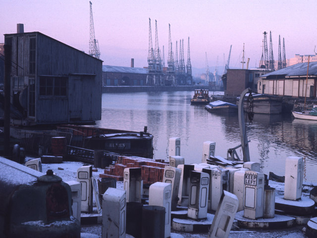
| Description |
English: Floating Harbour from Bristol Bridge This photograph was taken by my father in 1971, and shows the City Docks looking West from the South Side by Bristol Bridge. The two buildings on the right are (left to right) the Port Police Headquarters, now the River Station restaurant, and a boathouse built by Brunel, now the Severnshed restaurant. The housing development at Merchants Quay now occupies the site of the transit sheds in the middle distance. Comment by User:Jezhotwells: Actually this must be taken from Redcliffe Bridge, not Bristol Bridge as these building are not visible form Bristol Bridge. |
| Date | |
| Source | From geograph.org.uk |
| Author | Chris Heaton |
| Camera location | | View this and other nearby images on: OpenStreetMap |
|---|
_heading:247.00&language=en)
| Object location | | View this and other nearby images on: OpenStreetMap |
|---|
_heading:247.00&language=en)
Licensing

|
This image was taken from the Geograph project collection. See this photograph's page on the Geograph website for the photographer's contact details. The copyright on this image is owned by Chris Heaton and is licensed for reuse under the Creative Commons Attribution-ShareAlike 2.0 license.
|
This file is licensed under the Creative Commons Attribution-Share Alike 2.0 Generic license.
Attribution: Chris Heaton
- You are free:
- to share – to copy, distribute and transmit the work
- to remix – to adapt the work
- Under the following conditions:
- attribution – You must give appropriate credit, provide a link to the license, and indicate if changes were made. You may do so in any reasonable manner, but not in any way that suggests the licensor endorses you or your use.
- share alike – If you remix, transform, or build upon the material, you must distribute your contributions under the same or compatible license as the original.
File history
Click on a date/time to view the file as it appeared at that time.
| Date/Time | Thumbnail | Dimensions | User | Comment | |
|---|---|---|---|---|---|
| current | 21:31, 3 February 2011 | | 640 × 480 (96 KB) | GeographBot | == {{int:filedesc}} == {{Information |description={{en|1=Floating Harbour from Bristol Bridge This photograph was taken by my father in 1971, and shows the City Docks looking West from the South Side by Bristol Bridge. The two buildings on the right are ( |
File usage
The following pages on the English Wikipedia use this file (pages on other projects are not listed):
Global file usage
The following other wikis use this file:
- Usage on ar.wikipedia.org
- Usage on es.wikipedia.org