Size of this preview: 800 × 358 pixels. Other resolutions: 320 × 143 pixels | 964 × 431 pixels.
Original file (964 × 431 pixels, file size: 575 KB, MIME type: image/png)
| This is a file from the Wikimedia Commons. Information from its description page there is shown below. Commons is a freely licensed media file repository. You can help. |
Summary
| Description |
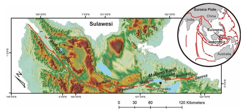
English: Map of the Matano and related faults on Sulawesi. Figure 1 from Daryono et al. 2021 |
| Date | |
| Source |
https://iopscience.iop.org/article/10.1088/1755-1315/873/1/012053/pdf |
| Author | Mudrik Rahmawan Daryono, Budhi Kumarawarman, Irpan Hidaya Muslim Rr. Triwurjani, Reza Permadi, Sukmandaru Prihatmoko, Setiyo Wibowo, Gde Handojo Tutuko |
Licensing
This file is licensed under the Creative Commons Attribution 3.0 Unported license.
- You are free:
- to share – to copy, distribute and transmit the work
- to remix – to adapt the work
- Under the following conditions:
- attribution – You must give appropriate credit, provide a link to the license, and indicate if changes were made. You may do so in any reasonable manner, but not in any way that suggests the licensor endorses you or your use.
File history
Click on a date/time to view the file as it appeared at that time.
| Date/Time | Thumbnail | Dimensions | User | Comment | |
|---|---|---|---|---|---|
| current | 16:47, 11 October 2023 | | 964 × 431 (575 KB) | Mikenorton | Uploaded a work by Mudrik Rahmawan Daryono, Budhi Kumarawarman, Irpan Hidaya Muslim Rr. Triwurjani, Reza Permadi, Sukmandaru Prihatmoko, Setiyo Wibowo, Gde Handojo Tutuko from https://iopscience.iop.org/article/10.1088/1755-1315/873/1/012053/pdf with UploadWizard |
File usage
The following pages on the English Wikipedia use this file (pages on other projects are not listed):