
Size of this preview: 800 × 598 pixels. Other resolutions: 320 × 239 pixels | 640 × 479 pixels | 1,024 × 766 pixels | 1,126 × 842 pixels.
Original file (1,126 × 842 pixels, file size: 311 KB, MIME type: image/png)
| This is a file from the Wikimedia Commons. Information from its description page there is shown below. Commons is a freely licensed media file repository. You can help. |
Summary
| Description |
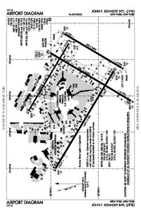
English: JFK Airport map, 2019
日本語: JFK空港の地図です |
| Date | |
| Source | FAA |
| Author |
Federal Aviation Administration; converted to png-file by Kontrollstelle Kundl, on 31 July 2023 |
| Other versions |
 |
| Camera location | | View this and other nearby images on: OpenStreetMap |
|---|
Licensing
This image or file is a work of a Federal Aviation Administration employee, taken or made as part of that person's official duties. As a work of the U.S. federal government, the image is in the public domain in the United States.
|
 |
File history
Click on a date/time to view the file as it appeared at that time.
| Date/Time | Thumbnail | Dimensions | User | Comment | |
|---|---|---|---|---|---|
| current | 17:01, 31 July 2023 | | 1,126 × 842 (311 KB) | Kontrollstellekundl | {{Rename|1=FAA JFK Airport map 2019.pdf|2=4|3=|user=Kontrollstellekundl}} =={{int:filedesc}}== {{Information |description = {{en|1=JFK Airport map, 2019}} {{ja|1=JFK空港の地図です}} |date = 2019-05-23 |source = [https://aeronav.faa.gov/d-tpp/1906/00610ad.pdf#nameddest=(JFK) FAA] |author = {{label|Q335357}};<br />converted to png-file by Kontrollstelle Kundl, {{date|2023-07-31}} |permission= |other versions= [[file:KJFK Airport Diagram 2019ver.pdf|thumb|2... |
File usage
The following pages on the English Wikipedia use this file (pages on other projects are not listed):
Global file usage
The following other wikis use this file:
- Usage on ban.wikipedia.org
- Usage on cs.wikipedia.org
- Usage on de.wikipedia.org
- Usage on es.wikipedia.org
- Usage on zh.wikipedia.org