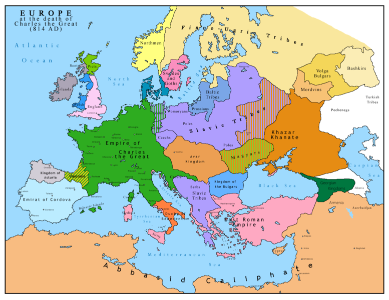
File:Europe 814.png

Original file (1,393 × 1,075 pixels, file size: 169 KB, MIME type: image/png)

Summary

Description
English: Map of Europe after the death of Charles the Great (814 AD). Original map made by Charles Colbeck, The Public Schools Historical Atlas (1905).
Date 2009-04-15. Source date: 1905 by Longmans, Green; New York, London, Bombay 1905.
Source Own work based on: Europe 814.jpg
Author Bukkia (talk · contribs)
Other versions
File:Europe 814.svg is a vector version of this file. It should be used in place of this PNG file when not inferior.

File:Europe 814.png → File:Europe 814.svg

For more information, see Help:SVG.

In other languages
Alemannisch  Bahasa Indonesia  Bahasa Melayu  British English  català  čeština  dansk  Deutsch  eesti  English  español  Esperanto  euskara  français  Frysk  galego  hrvatski  Ido  italiano  lietuvių  magyar  Nederlands  norsk bokmål  norsk nynorsk  occitan  Plattdüütsch  polski  português  português do Brasil  română  Scots  sicilianu  slovenčina  slovenščina  suomi  svenska  Tiếng Việt  Türkçe  vèneto  Ελληνικά  беларуская (тарашкевіца)  български  македонски  нохчийн  русский  српски / srpski  татарча/tatarça  українська  ქართული  հայերեն  বাংলা  தமிழ்  മലയാളം  ไทย  한국어  日本語  简体中文  繁體中文  עברית  العربية  فارسی  +/−
New SVG image

Licensing

Public domain I, the copyright holder of this work, release this work into the public domain. This applies worldwide.
In some countries this may not be legally possible; if so:
I grant anyone the right to use this work for any purpose, without any conditions, unless such conditions are required by law.
Maps of the history of Europe
BCE
aC

Weichselian ice age (c. 113,000–9700) · Neolithic expansion (c. 7000–4500) · Middle Neolithic (c. 4500–4000) · Late Neolithic (c. 4000–3000) · Copper Age – Corded Ware culture (c. 2900–2350) · Copper Age – Bellbeaker culture (c. 2800–1800) · Early Bronze Age – Unetice culture (c. 2300–1600) · Late Bronze Age – Urnfield culture (c. 1300—750) · Migrations (c. 1000–100) · Hallstatt & La Tène cultures (c. 800–100) · Roman Republic (510–40) · 220 · 218 · 200 · 201–100 · 58 · 49 · 39 · 30 BCE–6 CE


CE
dC

14 · 14–37 · 60 · 60 · 69 · 80 · Migrations 100–500 · 117 · 117 · 125 · Migrations 150–774 · Economy 180 · 271 · 293–305 · 337 · 395 · c. 395 · 400 · 400 · 450 · 457–61 · 476 · 480 · Franks 481–814 · Early Slavs 500–700 · 500 · 526 · 526–600 · Christianisation to 600 · c. 550 · 650 · Pontic Steppe 650 · 665 · 800 · Vikings 800–1050 · 814 · 843–70 · 850 · 900 · 912 · 998 · 1000 · 1000 · 1054 · 1092 · First Crusade 1095–99 · 1097 · 1135 · 1142 · 1147–49 · 1190 · 1190 · 1250 · c. 1250 · 1301-1400 · 1301-1400 · 1328 · 1345 · Black Plague 1347–51 · 1360 · 1400 · Trade routes c. 1400 · 1430 · 1470 · 1490 · 1492 · 1500 · 1519 · 1550 · 1560 · Religion 1560 · Religion 1600 · Religion 1618 · 1618–48 · 1648 · 1683 · 1700 · 1701 · 1708 · 1714 · 1721 · 1725–30 · 1739–1740 · 1740 · 1748–66 · 1783–1792 · 1787 · 1787 · 1789 · 1799 · 1812 · 1812 · 1812 · 1812 · 1813 · 1815 · 1815 · 1815 · 1818 · Ottoman Empire 1830–1923 · 1848–49 · 1861 · 1867 · 1871 · 1878 · 1890 · 1905 · 1911 · 1914 · 1914 · 1919 · 1919–29 · 1923 · 1929 · 1930 · 1940 · 1941–42 · 1942–45 · Cold War 1947–91 · 1950 · 1993–2006 · 2006 to date

(this template: · view · discuss )

Captions

I think this map is not clear and correct at all , where are the Moldavians and Transilvanians and other witch Romania now days is, plus the hungarians are from AVAR people

Items portrayed in this file

depicts

File history

Click on a date/time to view the file as it appeared at that time.

Date/TimeThumbnailDimensionsUserComment
current11:09, 26 April 2023Thumbnail for version as of 11:09, 26 April 20231,393 × 1,075 (169 KB)OrionNimrodReverted to version as of 13:52, 23 December 2015 (UTC) restore
16:09, 2 May 2019Thumbnail for version as of 16:09, 2 May 20191,370 × 1,047 (124 KB)Julieta39Slavs also in the Avars and Bulgars kingdoms
13:52, 23 December 2015Thumbnail for version as of 13:52, 23 December 20151,393 × 1,075 (169 KB)Ercwlffat that time armenia was already part of Arab caliphate.. and there were several Georgian kingdoms or principalities in the north of them
13:52, 8 June 2015Thumbnail for version as of 13:52, 8 June 20151,393 × 1,075 (157 KB)ZorionVasconia in rebellion
17:49, 28 May 2015Thumbnail for version as of 17:49, 28 May 20151,393 × 1,075 (156 KB)ZorionFrom 812 to 824, Vasconia was ruled by Vascons (sourced can be found anywhere in spanish, basque or french). This map was wrong for that specific year. Seems that historian wanted to credit a famous king but, he was dead when Wasconia got back under th...
15:58, 24 August 2014Thumbnail for version as of 15:58, 24 August 20141,393 × 1,075 (230 KB)Martin H.Reverted to version as of 14:53, 31 January 2010: File is consistent with its source file File:Europe 814.jpg; change conflicts with en:Duchy_of_Vasconia#Carolingian duchy (769–864)
14:42, 24 August 2014Thumbnail for version as of 14:42, 24 August 20141,393 × 1,075 (156 KB)ZorionVasconia was independant from frankish kingdom until 824
14:53, 31 January 2010Thumbnail for version as of 14:53, 31 January 20101,393 × 1,075 (230 KB)Bukkia== {{int:filedesc}} == {{Information |Description={{it|1=Mappa dell'Europa alla morte di Carlo Magno (814 d.C.)}} {{en|1=Map of Europe after the death of Charles the Great (814 AD, in Italian)}} |Source=Based on File:Europe 814.jpg |Author=[[user:Buk

Global file usage

The following other wikis use this file:

Metadata