
Size of this preview: 800 × 518 pixels. Other resolutions: 320 × 207 pixels | 640 × 415 pixels | 1,024 × 664 pixels | 1,534 × 994 pixels.
Original file (1,534 × 994 pixels, file size: 269 KB, MIME type: image/png)
| This is a file from the Wikimedia Commons. Information from its description page there is shown below. Commons is a freely licensed media file repository. You can help. |
Summary
| Description |
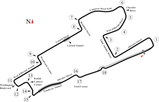
English: Track map of the former downtown Detroit street circuit. (Don't confuse this circuit with the one on Belle Isle.) This PNG is intended for use with browsers like IE7 that don't support SVG. |
| Date | |
| Source | Own work |
| Author | Will Pittenger |
| Other versions |
|

| Camera location | | View this and other nearby images on: OpenStreetMap |
|---|
Licensing
| I, the copyright holder of this work, release this work into the public domain. This applies worldwide. In some countries this may not be legally possible; if so: I grant anyone the right to use this work for any purpose, without any conditions, unless such conditions are required by law. |
File history
Click on a date/time to view the file as it appeared at that time.
| Date/Time | Thumbnail | Dimensions | User | Comment | |
|---|---|---|---|---|---|
| current | 11:39, 15 July 2008 | | 1,534 × 994 (269 KB) | Will Pittenger | {{Information |Description={{en|1=Track map of the former downtown w:Detroit street circuit. (Don't confuse this circuit with the one on w:Belle Isle.) This PNG is intended for use with browsers like IE7 that don't support SVG.}} |Source=Own w |
File usage
The following pages on the English Wikipedia use this file (pages on other projects are not listed):
- User talk:4u1e/archive5
- User talk:Bam123456789/Archive 1
- User talk:Barkjon/Archive 2
- User talk:Cdhaptomos/Archive 1
- User talk:Chubbennaitor/Archive7
- User talk:Chubbennaitor/archive2
- User talk:Clyde1998/Archive/2008
- User talk:Cs-wolves/Archive 3
- User talk:Donnie Park/Archive 1
- User talk:Hellboy2hell/archive2
- User talk:Midgrid/Archive 6
- User talk:NapHit/Archive 1
- User talk:Readro/Archive 3
- User talk:Sage Callahan/Archive 1
- User talk:Spenalzo/Archive/2008
- User talk:The359/Archive 4
- User talk:Thelb4/Archive 5
- User talk:Typ932/Archive 3
- Wikipedia:WikiProject Formula One/Newsletter/200808
Global file usage
The following other wikis use this file:
- Usage on bs.wikipedia.org
- Usage on cs.wikipedia.org
- Usage on pl.wikipedia.org
- Grand Prix Stanów Zjednoczonych – Wschód 1986
- Grand Prix Stanów Zjednoczonych – Wschód 1985
- Grand Prix Stanów Zjednoczonych – Wschód 1984
- Grand Prix Stanów Zjednoczonych – Wschód 1983
- Grand Prix Stanów Zjednoczonych – Wschód 1987
- Grand Prix Stanów Zjednoczonych – Wschód 1988
- Grand Prix Stanów Zjednoczonych – Wschód Formuły 1