
Size of this PNG preview of this SVG file: 643 × 599 pixels. Other resolutions: 258 × 240 pixels | 515 × 480 pixels | 824 × 768 pixels | 1,099 × 1,024 pixels | 2,198 × 2,048 pixels | 776 × 723 pixels.
Original file (SVG file, nominally 776 × 723 pixels, file size: 410 KB)
| This is a file from the Wikimedia Commons. Information from its description page there is shown below. Commons is a freely licensed media file repository. You can help. |
Summary
| Description |
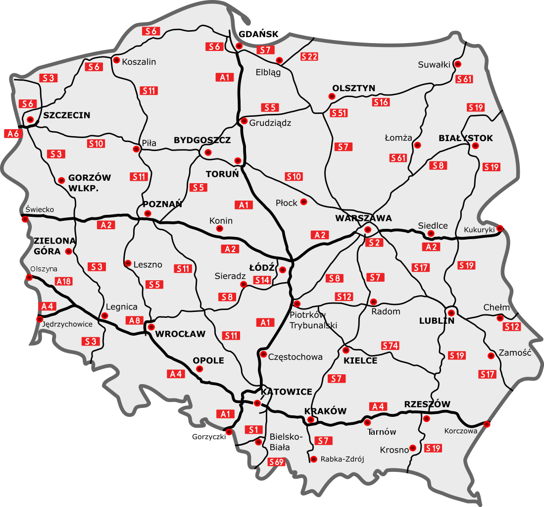
English: Map of the planned free and expressway network in Poland.
Esperanto: Fina sistemo de aŭtovojoj kaj rapidvojoj en Pollando.
Polski: Docelowy układ autostrad i dróg ekspresowych w Polsce.
Deutsch: Das Autobahn- und Schnellstraßennetz Polens, geplanter Endzustand.
Română: Sistemul planificat al autostrăzilor şi drumurilor de trafic accelerat în Polonia |
| Date | |
| Source |
Own work
|
| Author | Sliwers |
| SVG development |
Licensing
I, the copyright holder of this work, hereby publish it under the following license:
This file is licensed under the Creative Commons Attribution 3.0 Unported license.
- You are free:
- to share – to copy, distribute and transmit the work
- to remix – to adapt the work
- Under the following conditions:
- attribution – You must give appropriate credit, provide a link to the license, and indicate if changes were made. You may do so in any reasonable manner, but not in any way that suggests the licensor endorses you or your use.
File history
Click on a date/time to view the file as it appeared at that time.
| Date/Time | Thumbnail | Dimensions | User | Comment | |
|---|---|---|---|---|---|
| current | 12:11, 23 December 2015 | | 776 × 723 (410 KB) | Daniel749 | |
| 11:48, 23 December 2015 |  | 776 × 723 (411 KB) | Daniel749 | update | |
| 21:42, 5 January 2011 |  | 785 × 724 (165 KB) | Sliwers | + Grudziądz | |
| 12:14, 18 December 2010 |  | 785 × 724 (164 KB) | Sliwers | Various improvements | |
| 21:48, 10 December 2010 |  | 785 × 724 (161 KB) | Sliwers | Improved accuracy | |
| 17:29, 5 November 2009 |  | 785 × 724 (153 KB) | Sliwers | Minor tweaks to the S19 | |
| 18:20, 26 October 2009 |  | 785 × 724 (153 KB) | Sliwers | Next attempt | |
| 17:50, 26 October 2009 |  | 784 × 723 (153 KB) | Sliwers | Updated according to the newest version of the plan | |
| 16:31, 22 September 2009 |  | 784 × 723 (150 KB) | Sliwers | Zgorzelec/Jędrzychowice | |
| 18:21, 31 August 2009 |  | 784 × 723 (150 KB) | Sliwers | Colors |
File usage
The following pages on the English Wikipedia use this file (pages on other projects are not listed):
Global file usage
The following other wikis use this file:
- Usage on cs.wikipedia.org
- Usage on de.wikipedia.org
- Usage on fr.wikipedia.org
- Usage on it.wikipedia.org
- Usage on ko.wikipedia.org
- Usage on nl.wikipedia.org
- Usage on pl.wikipedia.org
- Usage on ru.wikipedia.org
- Usage on simple.wikipedia.org
- Usage on tr.wikipedia.org
- Usage on vi.wikipedia.org