Size of this preview: 800 × 294 pixels. Other resolutions: 320 × 117 pixels | 850 × 312 pixels.
Original file (850 × 312 pixels, file size: 142 KB, MIME type: image/png)
| This is a file from the Wikimedia Commons. Information from its description page there is shown below. Commons is a freely licensed media file repository. You can help. |
Summary
| Description |
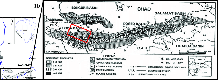
English: This is the image that was drawn out of the Topographic field of the Doba Basin (highlighted). |
| Date | |
| Source | https://www.researchgate.net/figure/Map-of-studied-location-red-box-Doba-Basin-of-Southern-Chad-which-is-a-part-of-Central_fig1_320723265 |
| Author | Ahmed Mohamed Ahmed Salim |
Licensing
This file is licensed under the Creative Commons Attribution 3.0 Unported license.
- You are free:
- to share – to copy, distribute and transmit the work
- to remix – to adapt the work
- Under the following conditions:
- attribution – You must give appropriate credit, provide a link to the license, and indicate if changes were made. You may do so in any reasonable manner, but not in any way that suggests the licensor endorses you or your use.
File history
Click on a date/time to view the file as it appeared at that time.
| Date/Time | Thumbnail | Dimensions | User | Comment | |
|---|---|---|---|---|---|
| current | 14:02, 23 April 2021 | 850 × 312 (142 KB) | TheMasterPlayer1112 | Uploaded a work by Ahmed Mohamed Ahmed Salim from https://www.researchgate.net/figure/Map-of-studied-location-red-box-Doba-Basin-of-Southern-Chad-which-is-a-part-of-Central_fig1_320723265 with UploadWizard |
File usage
The following pages on the English Wikipedia use this file (pages on other projects are not listed):