
Size of this PNG preview of this SVG file: 480 × 600 pixels. Other resolutions: 192 × 240 pixels | 384 × 480 pixels | 614 × 768 pixels | 819 × 1,024 pixels | 1,638 × 2,048 pixels | 1,000 × 1,250 pixels.
Original file (SVG file, nominally 1,000 × 1,250 pixels, file size: 364 KB)
| This is a file from the Wikimedia Commons. Information from its description page there is shown below. Commons is a freely licensed media file repository. You can help. |
Summary
| Description |
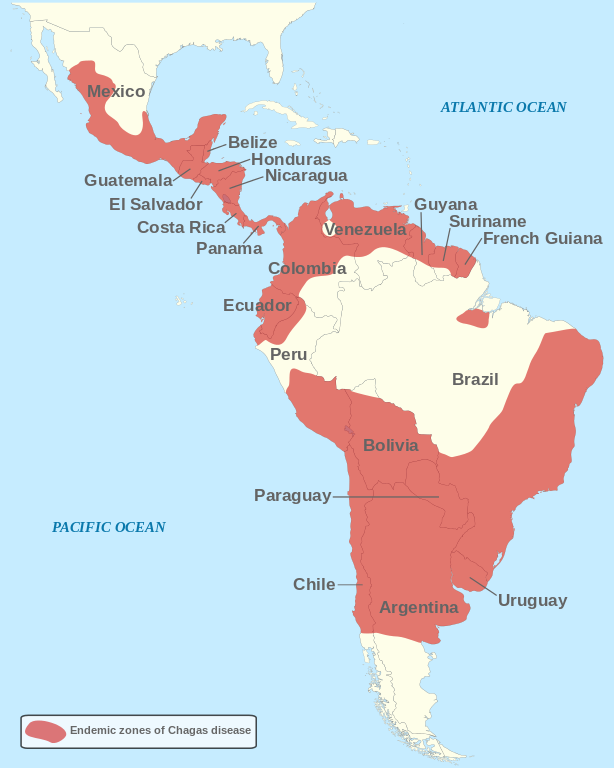
English: Geographical distribution of Chagas disease in Central and South America. Based on a map published by SpringerImages[1]. Français : Distribution géographique de la maladie de Chagas en Amérique Centrale et du Sud. Basé sur une carte publiée par SpringerImages[2]. Nederlands: Geografische distributie van de ziekte van Chagas in Centraal- en Zuid-Amerika. Gebaseerd op een kaart van SpringerImages[3]. Español: Distribución geográfica de la enfermedad de Chagas en América Central y del Sur. Basado en un mapa publicado por SpringerImages[4]. |
| Date | |
| Source | Own work |
| Author | Tomato356 |
| Other versions |
Translations:
|


|
This SVG file contains embedded text that can be translated into your language, using any capable SVG editor, text editor or the SVG Translate tool. For more information see: About translating SVG files. |
This W3C-unspecified vector image was created with Inkscape .
Licensing
I, the copyright holder of this work, hereby publish it under the following license:
This file is licensed under the Creative Commons Attribution-Share Alike 3.0 Unported license.
- You are free:
- to share – to copy, distribute and transmit the work
- to remix – to adapt the work
- Under the following conditions:
- attribution – You must give appropriate credit, provide a link to the license, and indicate if changes were made. You may do so in any reasonable manner, but not in any way that suggests the licensor endorses you or your use.
- share alike – If you remix, transform, or build upon the material, you must distribute your contributions under the same or compatible license as the original.
File history
Click on a date/time to view the file as it appeared at that time.
| Date/Time | Thumbnail | Dimensions | User | Comment | |
|---|---|---|---|---|---|
| current | 10:41, 6 September 2012 | | 1,000 × 1,250 (364 KB) | Tomato356 | Adjusted distribution zone, added country names, ocean names and a legend. |
| 18:09, 5 September 2012 |  | 1,000 × 1,250 (335 KB) | Tomato356 | Small correction of the distribution. | |
| 17:55, 5 September 2012 |  | 1,000 × 1,250 (336 KB) | Tomato356 | Added background and optimised visibility. | |
| 17:41, 5 September 2012 |  | 1,000 × 1,250 (322 KB) | Tomato356 | User created page with UploadWizard |
File usage
The following pages on the English Wikipedia use this file (pages on other projects are not listed):
Global file usage
The following other wikis use this file:
- Usage on ar.wikipedia.org
- Usage on de.wikipedia.org
- Usage on he.wikipedia.org
- Usage on it.wikipedia.org
- Usage on nl.wikipedia.org
- Usage on pl.wikipedia.org
- Usage on pt.wikipedia.org
- Usage on ru.wikipedia.org