
Size of this preview: 800 × 581 pixels. Other resolutions: 320 × 232 pixels | 640 × 465 pixels | 1,024 × 744 pixels | 1,280 × 930 pixels | 1,600 × 1,162 pixels.
Original file (1,600 × 1,162 pixels, file size: 2 MB, MIME type: image/jpeg)
| This is a file from the Wikimedia Commons. Information from its description page there is shown below. Commons is a freely licensed media file repository. You can help. |
| Description |
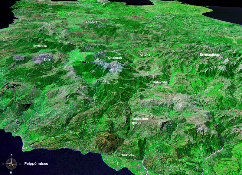
Peloponnese, north==>south, altitude: 20 km; Landsat7, GeoCover 2000, res. 15m/pix |
| Date | |
| Source | installed WW-Software needed: worldwind://goto/world=Earth&lat=38.05234&lon=22.18076&alt=20000&dir=180&tilt=60 |
| Author | Photograph: NASA |
| This image is in the public domain because it is a screenshot from NASA’s globe software World Wind using a public domain layer, such as Blue Marble, MODIS, Landsat, SRTM, USGS or GLOBE.
|
 |
File history
Click on a date/time to view the file as it appeared at that time.
| Date/Time | Thumbnail | Dimensions | User | Comment | |
|---|---|---|---|---|---|
| current | 22:22, 2 October 2006 | | 1,600 × 1,162 (2 MB) | Ulrichstill | {{Information| |Description = Peloponnese, north==>south, altitude: 20 km; Landsat7, GeoCover 2000, res. 15m/pix <br> Vorne: Golf von Korinth; Schwemmkegel des Flusses Vouraikos bei Diakoptó. Das nach Kalavrita beginnende Gefälle des Flusses schuf die S |
File usage
No pages on the English Wikipedia use this file (pages on other projects are not listed).
Global file usage
The following other wikis use this file:
- Usage on de.wikipedia.org
- Usage on el.wikipedia.org
- Usage on it.wikipedia.org
- Usage on pl.wikipedia.org
- Usage on ru.wikipedia.org
- Usage on www.wikidata.org