Original file (1,051 × 708 pixels, file size: 267 KB, MIME type: image/jpeg)
| This is a file from the Wikimedia Commons. Information from its description page there is shown below. Commons is a freely licensed media file repository. You can help. |
Summary
| Description |
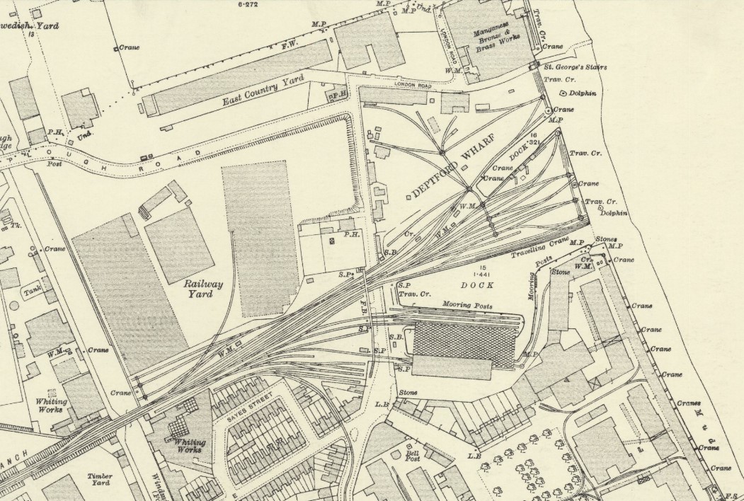
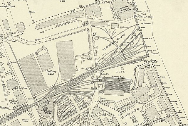
English: Ordnance Survey Map of Deptford Wharf and surroundings, revised 1914, published 1916. |
| Date | |
| Source | https://maps.nls.uk/view/103313393 |
| Author | Ordnance Survey |
The map shows at the top South Dock (in 19th century called East Country Dock) which is still extant and used as a marina, and at Deptford Wharf there is Dudman's Dock (incorrectly called Deadman's Dock on some maps), and South of that the larger wet dock - called Gordon's Dock on some maps. The south part of that dock (the hatched area) is a covered area for handling goods that would spoil in heavy rain, such as flour, etc. The railway branch serving the docks was built in 1848. The rail jetty into the dock was built sometime between 1894 and 1914, as it is not present on the 1894 map. To the South of Gordon's dock is the Navy Victualling Yard - a large area, formerly gardens, that was in use until 1961. A branch off the railway, built c1900, travels South down the centre of Grove Street serving the Victualling Yard and the foreign cattle market. Further south still (and not on the map) are the Deptford Naval Dockyards, which were in use until 1869. Both naval and commercial shipping were built at Deptford Wharf up to 1812.
Licensing
This work is in the public domain in the United States because it was published (or registered with the U.S. Copyright Office) before January 1, 1929.
Public domain works must be out of copyright in both the United States and in the source country of the work in order to be hosted on the Commons. If the work is not a U.S. work, the file must have an additional copyright tag indicating the copyright status in the source country.
Note: This tag should not be used for sound recordings. |
File history
Click on a date/time to view the file as it appeared at that time.
| Date/Time | Thumbnail | Dimensions | User | Comment | |
|---|---|---|---|---|---|
| current | 10:58, 5 February 2022 | | 1,051 × 708 (267 KB) | Oldnoccer | Uploaded a work by Ordnance Survey from https://maps.nls.uk/view/103313393 with UploadWizard |