No higher resolution available.
Crackington_Haven.jpg (640 × 480 pixels, file size: 47 KB, MIME type: image/jpeg)
| This is a file from the Wikimedia Commons. Information from its description page there is shown below. Commons is a freely licensed media file repository. You can help. |
| Description |
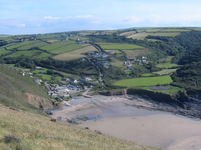
English: Crackington Haven, Cornwall. Taken from the cliff around SX140972, but covering a good proportion of the SX1496 grid square with Crackington Haven nestling at the bottom of the valley. This was taken in 2003, before the 2004 floods which washed away the car park and footbridge. |
| Date | |
| Source | From geograph.org.uk |
| Author | Paul Dixon |
| Permission (Reusing this file) |
Creative Commons Attribution Share-alike license 2.0 |
| Camera location | | View this and other nearby images on: OpenStreetMap |
|---|

|
This image was taken from the Geograph project collection. See this photograph's page on the Geograph website for the photographer's contact details. The copyright on this image is owned by Paul Dixon and is licensed for reuse under the Creative Commons Attribution-ShareAlike 2.0 license.
|
This file is licensed under the Creative Commons Attribution-Share Alike 2.0 Generic license.
Attribution: Paul Dixon
- You are free:
- to share – to copy, distribute and transmit the work
- to remix – to adapt the work
- Under the following conditions:
- attribution – You must give appropriate credit, provide a link to the license, and indicate if changes were made. You may do so in any reasonable manner, but not in any way that suggests the licensor endorses you or your use.
- share alike – If you remix, transform, or build upon the material, you must distribute your contributions under the same or compatible license as the original.
Original upload log
The original description page was here. All following user names refer to en.wikipedia.
- 2007-12-05 11:11 Rodw 640×480×8 (48514 bytes) Crackington Haven Taken from the cliff around SX140972, but covering a good proportion of the SX1496 grid square with Crackington Haven nestling at the bottom of the valley. This was taken in 2003, before the 2004 floods which washed away the car park and
File history
Click on a date/time to view the file as it appeared at that time.
| Date/Time | Thumbnail | Dimensions | User | Comment | |
|---|---|---|---|---|---|
| current | 22:23, 14 July 2008 | | 640 × 480 (47 KB) | Angusmclellan | {{Information |Description={{en|Crackington Haven, Cornwall. Taken from the cliff around SX140972, but covering a good proportion of the SX1496 grid square with Crackington Haven nestling at the bottom of the valley. This was taken in 2003, before the 200 |
File usage
The following pages on the English Wikipedia use this file (pages on other projects are not listed):
Global file usage
The following other wikis use this file:
- Usage on eu.wikipedia.org
- Usage on hu.wikipedia.org
- Usage on kw.wikipedia.org