No higher resolution available.
Count_Kocel's_territories.PNG (737 × 546 pixels, file size: 100 KB, MIME type: image/png)
| This is a file from the Wikimedia Commons. Information from its description page there is shown below. Commons is a freely licensed media file repository. You can help. |
Summary
| Description |
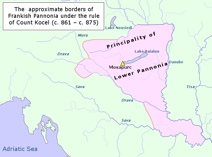
English: Count Kocel's territories in the 9th century; (For approximate borders look at Inzko Valentin (1978): Zgodovina Slovencev do leta 1918. Mohorjeva založba, Celovec, page: 34; Čepič Zdenko et al. (1979): Zgodovina Slovencev. Cankarjeva založba, Ljubljana 1979, page: 127, 133; Peršič Janez et al. (1983): Stare kulture. Mladinska knjiga, Ljubljana, page: 144;) |
| Date | |
| Source | Own work (it is based on a public domain map File:Pannonian Slavic Duchy-cro.PNG) |
| Author | Fakirbakir |
Licensing
I, the copyright holder of this work, hereby publish it under the following license:
This file is licensed under the Creative Commons Attribution-Share Alike 3.0 Unported license.
- You are free:
- to share – to copy, distribute and transmit the work
- to remix – to adapt the work
- Under the following conditions:
- attribution – You must give appropriate credit, provide a link to the license, and indicate if changes were made. You may do so in any reasonable manner, but not in any way that suggests the licensor endorses you or your use.
- share alike – If you remix, transform, or build upon the material, you must distribute your contributions under the same or compatible license as the original.
File history
Click on a date/time to view the file as it appeared at that time.
| Date/Time | Thumbnail | Dimensions | User | Comment | |
|---|---|---|---|---|---|
| current | 12:52, 4 April 2014 | | 737 × 546 (100 KB) | Fakirbakir | User created page with UploadWizard |
File usage
No pages on the English Wikipedia use this file (pages on other projects are not listed).
Global file usage
The following other wikis use this file:
- Usage on cs.wikipedia.org
- Usage on et.wikipedia.org
- Usage on hu.wikipedia.org
- Usage on id.wikipedia.org
- Usage on it.wikipedia.org
- Usage on ja.wikipedia.org
- Usage on pl.wikipedia.org
- Usage on pt.wikipedia.org