_map.png)
_map.png&action=edit&redlink=1)
No higher resolution available.
Cook_Islands_(New_Zealand)_map.png (324 × 348 pixels, file size: 15 KB, MIME type: image/png)
| This is a file from the Wikimedia Commons. Information from its description page there is shown below. Commons is a freely licensed media file repository. You can help. |
_map.png)
Summary
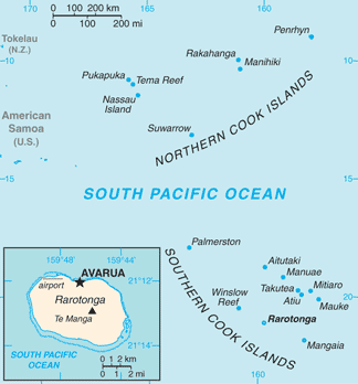
| Description |
English: Map of Cook Islands (New Zealand)
Italiano: Mappa delle Isole Cook (Nuova Zelanda) |
|||
| Date | ||||
| Source | https://www.cia.gov/library/publications/the-world-factbook/geos/cw.html | |||
| Author | Directorate of Intelligence, CIA | |||
| Permission (Reusing this file) |
|
Licensing
This image is in the public domain because it contains materials that originally came from the United States Central Intelligence Agency's World Factbook.
|
 |
Original upload log
| Date/Time | Dimensions | User | Comment |
|---|---|---|---|
| 16 March 2013, 18:45:06 | 328 × 353 (19796 bytes) | Edoardo Cavaleri (talk · contribs) | {{Information |Description ={{en|1=Map of Cook Islands (New Zealand)}} {{it|1=Mappa delle Isole Cook (Nuova Zelanda)}} |Source =https://www.cia.gov/library/publications/the-world-factbook/geos/cw.html |Author =Directorate of Intellig... |
File history
Click on a date/time to view the file as it appeared at that time.
| Date/Time | Thumbnail | Dimensions | User | Comment | |
|---|---|---|---|---|---|
| current | 05:16, 13 February 2022 | | 324 × 348 (15 KB) | Lojwe | Cropped 1 % horizontally, 1 % vertically using CropTool with precise mode. |
| 11:38, 25 November 2014 |  | 328 × 353 (19 KB) | GifTagger | Bot: Converting file to superior PNG file. (Source: Cook_Islands_(New_Zealand)_map.gif). This GIF was problematic due to non-greyscale color table. |
_map.gif)
File usage
The following pages on the English Wikipedia use this file (pages on other projects are not listed):
Global file usage
The following other wikis use this file:
- Usage on ar.wikipedia.org
- Usage on ast.wikipedia.org
- Usage on ca.wikipedia.org
- Usage on co.wikipedia.org
- Usage on de.wikipedia.org
- Usage on el.wikipedia.org
- Usage on es.wikipedia.org
- Usage on fr.wikipedia.org
- Usage on gl.wikipedia.org
- Usage on hif.wikipedia.org
- Usage on incubator.wikimedia.org
- Usage on io.wikipedia.org
- Usage on it.wikipedia.org
- Usage on ja.wikipedia.org
- Usage on mt.wikipedia.org
- Usage on pt.wikipedia.org
- Usage on ro.wikipedia.org
- Usage on ru.wikipedia.org
- Usage on sr.wikipedia.org
- Usage on test.wikidata.org
- Usage on tg.wikipedia.org
- Usage on th.wikipedia.org
- Usage on tl.wikipedia.org
- Usage on uk.wikipedia.org
- Usage on www.wikidata.org
- Usage on zh.wikipedia.org
_map.png)