No higher resolution available.
Congo-Brazzaville.png (100 × 116 pixels, file size: 3 KB, MIME type: image/png)
| This is a file from the Wikimedia Commons. Information from its description page there is shown below. Commons is a freely licensed media file repository. You can help. |
| Description |
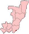
Map of the Republic of the Congo showing Brazzaville commune. Türkçe: Kongo Cumhuriyeti Haritasında Brazavil |
| Date | |
| Source | Self-made, traced from public domain UN or CIA maps. |
| Author | User:Golbez |
| Permission (Reusing this file) |
Provide attribution, please. See below. |
| Other versions | See Image:Congo regions named.png for the map of the regions. |
I, the copyright holder of this work, hereby publish it under the following licenses:
This file is licensed under the Creative Commons Attribution-Share Alike 2.5 Generic, 2.0 Generic and 1.0 Generic license.
- You are free:
- to share – to copy, distribute and transmit the work
- to remix – to adapt the work
- Under the following conditions:
- attribution – You must give appropriate credit, provide a link to the license, and indicate if changes were made. You may do so in any reasonable manner, but not in any way that suggests the licensor endorses you or your use.
- share alike – If you remix, transform, or build upon the material, you must distribute your contributions under the same or compatible license as the original.

|
Permission is granted to copy, distribute and/or modify this document under the terms of the GNU Free Documentation License, Version 1.2 or any later version published by the Free Software Foundation; with no Invariant Sections, no Front-Cover Texts, and no Back-Cover Texts. A copy of the license is included in the section entitled GNU Free Documentation License. |
| This file is licensed under the Creative Commons Attribution-Share Alike 3.0 Unported license. | ||
| ||
| This licensing tag was added to this file as part of the GFDL licensing update. |
You may select the license of your choice.
File history
Click on a date/time to view the file as it appeared at that time.
| Date/Time | Thumbnail | Dimensions | User | Comment | |
|---|---|---|---|---|---|
| current | 20:47, 30 September 2023 | | 100 × 116 (3 KB) | Yunan973 | add transparency |
| 20:41, 30 September 2023 |  | 100 × 116 (7 KB) | Yunan973 | fix all boundaries according to last offical maps (2023) | |
| 10:36, 22 July 2007 |  | 100 × 116 (2 KB) | Bemoeial~commonswiki | Reverted to earlier revision | |
| 10:35, 22 July 2007 |  | 332 × 355 (8 KB) | Bemoeial~commonswiki | {{PD-USGov}} original: en:Image:Congo republic sm04.png Category:Maps of the Republic of the Congo | |
| 03:55, 28 December 2004 |  | 100 × 116 (2 KB) | Golbez | Map of the Republic of the Congo showing Brazzaville region. Made by User:Golbez. {{cc-by-sa-2.0}} |
File usage
No pages on the English Wikipedia use this file (pages on other projects are not listed).
Global file usage
The following other wikis use this file:
- Usage on ar.wikipedia.org
- Usage on arz.wikipedia.org
- Usage on ast.wikipedia.org
- Usage on ca.wikipedia.org
- Usage on diq.wikipedia.org
- Usage on el.wikipedia.org
- Usage on es.wikipedia.org
- Usage on eu.wikipedia.org
- Usage on fr.wikipedia.org
- Usage on ga.wikipedia.org
- Usage on gd.wikipedia.org
- Usage on gl.wikipedia.org
- Usage on ha.wikipedia.org
- Usage on ht.wikipedia.org
- Usage on hu.wikipedia.org
- Usage on ia.wikipedia.org
- Usage on incubator.wikimedia.org
- Usage on io.wikipedia.org
- Usage on kab.wikipedia.org
- Usage on kg.wikipedia.org
- Usage on la.wikipedia.org
- Usage on mdf.wikipedia.org
- Usage on mzn.wikipedia.org
- Usage on nds.wikipedia.org
- Usage on nov.wikipedia.org
- Usage on oc.wikipedia.org
- Usage on ro.wikipedia.org
- Usage on uk.wikipedia.org
- Usage on vi.wikipedia.org
- Usage on vo.wikipedia.org
- Usage on www.wikidata.org
- Usage on wo.wikipedia.org