
Original file (770 × 873 pixels, file size: 732 KB, MIME type: image/jpeg)
| This is a file from the Wikimedia Commons. Information from its description page there is shown below. Commons is a freely licensed media file repository. You can help. |
Summary
| Description |
English: * "Imprimatur, Gu. Paynter, vice-can., Oxon., Sept. 28, 1700."
|
||
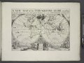
| Title | A new map of the terraqueous globe according to the latest discoveries and most general divisions of it into continents and oceans. | ||
| Alternative title | Present world. | ||
| Date | |||
| Source | https://digitalcollections.nypl.org/items/510d47e4-524f-a3d9-e040-e00a18064a99 | ||
| Author | Scan by NYPL | ||
| Permission (Reusing this file) |
|
||
| Other versions |
|
||
| UUID | cd277640-c5d3-012f-77e8-58d385a7bc34 | ||
| MODS | http://api.repo.nypl.org/api/v1/items/mods/510d47e4-524f-a3d9-e040-e00a18064a99 | ||
| Origin place | Printed at the Theater, | ||
| Image ID | 1630698 | ||
| Collection | Lawrence H. Slaughter Collection of English maps, charts, globes, books and atlases | ||
| Collection UUID | 510d47e4-524f-a3d9-e040-e00a18064a99 | ||
| NYPL catalog ID | b15114268 | ||
| NYPL Division | Lionel Pincus and Princess Firyal Map Division | ||
| Topics | Atlases, British; Geography, Ancient; Maps in education |
.jpg)
Licensing
This image is in the public domain because it is a mere mechanical scan or photocopy of a public domain original, or – from the available evidence – is so similar to such a scan or photocopy that no copyright protection can be expected to arise. The original itself is in the public domain for the following reason:
This tag is designed for use where there may be a need to assert that any enhancements (eg brightness, contrast, colour-matching, sharpening) are in themselves insufficiently creative to generate a new copyright. It can be used where it is unknown whether any enhancements have been made, as well as when the enhancements are clear but insufficient. For known raw unenhanced scans you can use an appropriate {{PD-old}} tag instead. For usage, see Commons:When to use the PD-scan tag.  | ||||
File history
Click on a date/time to view the file as it appeared at that time.
| Date/Time | Thumbnail | Dimensions | User | Comment | |
|---|---|---|---|---|---|
| current | 14:23, 19 January 2023 | | 770 × 873 (732 KB) | LlywelynII | File:A new map of the terraqueous globe according to the latest discoveries and most general divisions of it into continents and oceans (NYPL b15114268-1630698).jpg cropped using CropTool. |
.jpg)
File usage
Global file usage
The following other wikis use this file:
- Usage on www.wikidata.org