
Size of this preview: 800 × 507 pixels. Other resolutions: 320 × 203 pixels | 640 × 406 pixels | 1,024 × 649 pixels | 1,332 × 844 pixels.
Original file (1,332 × 844 pixels, file size: 408 KB, MIME type: image/jpeg)
| This is a file from the Wikimedia Commons. Information from its description page there is shown below. Commons is a freely licensed media file repository. You can help. |
Summary

|
This locator map image could be re-created using vector graphics as an SVG file. This has several advantages; see Commons:Media for cleanup for more information. If an SVG form of this image is available, please upload it and afterwards replace this template with
{{vector version available|new image name}}.
It is recommended to name the SVG file “Clifton-Cincinnati-map.svg”—then the template Vector version available (or Vva) does not need the new image name parameter. |


| Description |
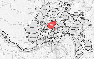
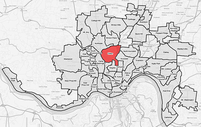
English: A map of the neighborhood of Clifton within Cincinnati, Ohio. Neighborhood lines are based on information from http://www.cincinnati-oh.gov/police/pages/-5095-/. This street map is derived from a free http://www.openstreetmap.org/ map. |
| Date | |
| Source | http://www.openstreetmap.org/ |
| Author | Wholtone |
| Permission (Reusing this file) |
This file is licensed under the Creative Commons Attribution-Share Alike 2.0 Generic license.
|
Licensing
I, the copyright holder of this work, hereby publish it under the following license:
This file is licensed under the Creative Commons Attribution 3.0 Unported license.
- You are free:
- to share – to copy, distribute and transmit the work
- to remix – to adapt the work
- Under the following conditions:
- attribution – You must give appropriate credit, provide a link to the license, and indicate if changes were made. You may do so in any reasonable manner, but not in any way that suggests the licensor endorses you or your use.
File history
Click on a date/time to view the file as it appeared at that time.
| Date/Time | Thumbnail | Dimensions | User | Comment | |
|---|---|---|---|---|---|
| current | 18:28, 9 August 2008 | | 1,332 × 844 (408 KB) | Wholtone | More accurate borders. |
| 18:25, 9 August 2008 |  | 1,332 × 844 (410 KB) | Wholtone | Fixed misspelling of "cumminsville" Category:Map | |
| 03:31, 4 August 2008 |  | 1,332 × 844 (409 KB) | Wholtone | {{Information |Description={{en|1=A map of the neighborhood of Clifton within Cincinnati, Ohio. Neighborhood lines are based on information from http://www.cincinnati-oh.gov/police/pages/-5095-/. This street map is derived from a free http://www.openstree |
File usage
The following pages on the English Wikipedia use this file (pages on other projects are not listed):