.svg)
.svg&action=edit&redlink=1)

Size of this PNG preview of this SVG file: 800 × 457 pixels. Other resolutions: 320 × 183 pixels | 640 × 366 pixels | 1,024 × 585 pixels | 1,280 × 731 pixels | 2,560 × 1,463 pixels | 1,120 × 640 pixels.
Original file (SVG file, nominally 1,120 × 640 pixels, file size: 6.57 MB)
| This is a file from the Wikimedia Commons. Information from its description page there is shown below. Commons is a freely licensed media file repository. You can help. |
.svg)
Summary
| Description |
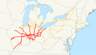
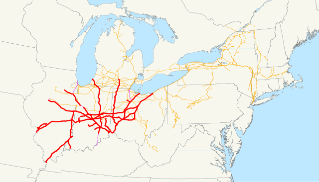
This is a map of the Cleveland, Cincinnati, Chicago and St. Louis Railway (Big Four) drawn on the New York Central system as of 1918, with trackage rights in purple. Email me if you would like a copy of the GIS data I created (modified from Bureau of Transportation Statistics North American Transportation Atlas Data) or if you see any errors. This map includes all companies leased by the Big Four, as well as the following operating subsidiaries:
It does not include the following:
|
| Date | 9 November 2008 (original upload date) |
| Source | No machine-readable source provided. Own work assumed (based on copyright claims). |
| Author | No machine-readable author provided. NE2 assumed (based on copyright claims). |
Licensing
| I, the copyright holder of this work, release this work into the public domain. This applies worldwide. In some countries this may not be legally possible; if so: I grant anyone the right to use this work for any purpose, without any conditions, unless such conditions are required by law. |
File history
Click on a date/time to view the file as it appeared at that time.
| Date/Time | Thumbnail | Dimensions | User | Comment | |
|---|---|---|---|---|---|
| current | 21:18, 9 November 2008 | | 1,120 × 640 (6.57 MB) | NE2 | == Summary == This is a map of the Cleveland, Cincinnati, Chicago and St. Louis Railway (Big Four) drawn on the New York Central system as of 1918, with trackage rights in purple. Email me if you would like |
File usage
No pages on the English Wikipedia use this file (pages on other projects are not listed).
Global file usage
The following other wikis use this file:
- Usage on de.wikipedia.org
- Usage on fr.wikipedia.org
- Usage on www.wikidata.org
.svg)