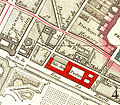
File:Cirque du Mont Thabor on 1814 map of Paris - U of Chicago.jpg

Original file(947 × 831 pixels, file size: 752 KB, MIME type: image/jpeg)

Summary

Description
English: The Cirque du Mont Thabor [ marked Cirque Olympiq de Franconi ] on an 1814 map of Paris
Date
Source This file was derived from: Picquet map of Paris 1814 - U of Chicago left half 400 dpi.jpg
English: Detail from the original.
Author

Cartographer :  

Charles Picquet  (1771–1827)  wikidata:Q16855741
 
Description French cartographer and geographer
Date of birth/death 15 April 1771 Edit this at Wikidata 15 January 1827 Edit this at Wikidata
Location of birth/death Paris
Work period 1786 Edit this at Wikidata–1827 Edit this at Wikidata
Work location
Authority file
creator QS:P170,Q16855741

Licensing

Public domain

This work is in the public domain in its country of origin and other countries and areas where the copyright term is the author's life plus 100 years or fewer.


You must also include a United States public domain tag to indicate why this work is in the public domain in the United States.

Captions

Add a one-line explanation of what this file represents

Items portrayed in this file

depicts

image/jpeg

7d52f62551cf627bd19f1bfbefc833af403f2349

770,492 byte

831 pixel

947 pixel

File history

Click on a date/time to view the file as it appeared at that time.

Date/TimeThumbnailDimensionsUserComment
current09:08, 8 September 2013Thumbnail for version as of 09:08, 8 September 2013947 × 831 (752 KB)Robert.Allen{{Information |Description ={{en|1=The Cirque du Mont Thabor [ marked Cirque Olympiq de Franconi ] on an 1814 map of Paris}} |Source ={{Derived from|Picquet map of Paris 1814 - U of Chicago left half 400 dpi.jpg}} {{en|Detail from the origin...
The following pages on the English Wikipedia use this file (pages on other projects are not listed):

Global file usage

The following other wikis use this file:

Metadata