.jpg)
.jpg&action=edit&redlink=1)

Size of this preview: 800 × 533 pixels. Other resolutions: 320 × 213 pixels | 640 × 427 pixels | 1,024 × 683 pixels | 1,280 × 853 pixels | 2,560 × 1,707 pixels | 5,568 × 3,712 pixels.
Original file (5,568 × 3,712 pixels, file size: 13.57 MB, MIME type: image/jpeg)
| This is a file from the Wikimedia Commons. Information from its description page there is shown below. Commons is a freely licensed media file repository. You can help. |
.jpg)
Summary
| Description |
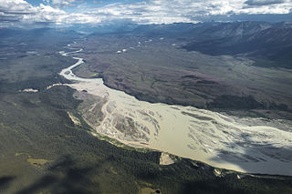
NPS / Jacob W. Frank Flight paths: caltopo.com/m/031C English: Chitina River Below the Nizina River and Chakina River Confluences
Deutsch: Chitina River unterhalb der Einmündung von Nizina River (links im Bild) und Chakina River (rechts im Hintergrund) |
| Date | |
| Source | Chitina River Below the Nizina River and Chakina River Confluences |
| Author | National Park Service, Alaska Region |
| Camera location | | View this and other nearby images on: OpenStreetMap |
|---|
.jpg¶ms=061.374630_N_-143.347940_E_globe:Earth_type:camera__&language=en)
Licensing
| This image or media file contains material based on a work of a National Park Service employee, created as part of that person's official duties. As a work of the U.S. federal government, such work is in the public domain in the United States. See the NPS website and NPS copyright policy for more information. |
File history
Click on a date/time to view the file as it appeared at that time.
| Date/Time | Thumbnail | Dimensions | User | Comment | |
|---|---|---|---|---|---|
| current | 17:35, 4 January 2016 | | 5,568 × 3,712 (13.57 MB) | Holly Cheng | Transferred from Flickr via Flickr2Commons |
File usage
The following pages on the English Wikipedia use this file (pages on other projects are not listed):
Global file usage
The following other wikis use this file:
- Usage on de.wikipedia.org
.jpg)