
Size of this PNG preview of this SVG file: 600 × 600 pixels. Other resolutions: 240 × 240 pixels | 480 × 480 pixels | 768 × 768 pixels | 1,024 × 1,024 pixels | 2,048 × 2,048 pixels | 625 × 625 pixels.
Original file (SVG file, nominally 625 × 625 pixels, file size: 84 KB)
| This is a file from the Wikimedia Commons. Information from its description page there is shown below. Commons is a freely licensed media file repository. You can help. |
| Description |
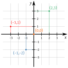
English: A small portion of the Cartesian coordinate system, showing the origin, axes, and the four quadrants, with illustrative points and grid. Part of a series in elementary mathematics.
Español: Una porción del plano cartesiano. Parte de una serie en matemáticas elementales. |
| Date | (UTC) |
| Source | |
| Author |
|
This W3C-unspecified vector image was created with Inkscape .
| This is a retouched picture, which means that it has been digitally altered from its original version. Modifications: small cosmetic changes to homogenize. The original can be viewed here: Cartesian-coordinate-system.svg:
|
| I, the copyright holder of this work, release this work into the public domain. This applies worldwide. In some countries this may not be legally possible; if so: I grant anyone the right to use this work for any purpose, without any conditions, unless such conditions are required by law. |
Original upload log
This image is a derivative work of the following images:
- File:Cartesian-coordinate-system.svg licensed with Cc-by-sa-3.0-migrated, GFDL, PD-user
- 2011-07-22T03:11:37Z Johnuniq 354x354 (53727 Bytes) remove left and down arrows on each axis per talk
- 2008-09-08T08:57:40Z Kbolino 354x354 (54425 Bytes) missed the y
- 2008-09-08T08:54:04Z Kbolino 354x354 (50985 Bytes) brute force: fonts to paths (the sans-serif text is DejaVu Sans, which is a PD modification to Bitstream Vera Sans, license at http://dejavu.sourceforge.net/wiki/index.php/License; the serif text is Gentium, under the SIL Ope
- 2008-09-08T08:45:23Z Kbolino 354x354 (27155 Bytes) fix fonts (hopefully)
- 2008-09-08T08:26:12Z Kbolino 354x354 (24182 Bytes) {{Information |Description=A small portion of the Cartesian coordinate system, showing the origin, axes, and the four quadrants, with illustrative points and grid. |Source=Made by K. Bolino ([[User:Kbolino|Kbolino]]), based u
- 2007-06-22T06:21:24Z Cronholm144 429x425 (21450 Bytes) tweaked image
- 2006-06-16T12:36:22Z Helix84 770x790 (8555 Bytes) {{Information| |Description= |Source= |Date= |Author=User [[:en:User:345Kai|345Kai]] on [http://en.wikipedia.org en.wikipedia] |Permission={{GFDL-user-w|en|wikipedia|345Kai}} |other_versions= Originally from [http://en.wikip
Uploaded with derivativeFX
File history
Click on a date/time to view the file as it appeared at that time.
| Date/Time | Thumbnail | Dimensions | User | Comment | |
|---|---|---|---|---|---|
| current | 14:08, 9 August 2011 | | 625 × 625 (84 KB) | Kismalac | {{Information |Description={{en|1=A small portion of the Cartesian coordinate system, showing the origin, axes, and the four quadrants, with illustrative points and grid.}} {{es|1=Una porción del plano cartesiano.}} |Source=*[[:File:Cartesian-coordinate- |
File usage
No pages on the English Wikipedia use this file (pages on other projects are not listed).
Global file usage
The following other wikis use this file:
- Usage on es.wikipedia.org
- Usage on fr.wiktionary.org