No higher resolution available.
Canyards_Hill_-_geograph.org.uk_-_980163.jpg (640 × 480 pixels, file size: 118 KB, MIME type: image/jpeg)
| This is a file from the Wikimedia Commons. Information from its description page there is shown below. Commons is a freely licensed media file repository. You can help. |
Summary
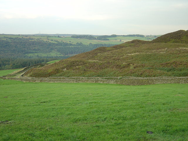
| Description |
English: Canyards Hill The rough outline suggests evidence of quarrying, but is in fact natural. The area is a Site of Special Scientific Interest (SSSI), the citation for which includes the following:
"This site possesses the most impressive examples in England and Wales of the topographic features known as 'ridge-and-trough' or 'tumbled ground'. Beneath a 10 m high cliff the north-facing valleyside above Broomhead Reservoir is a chaotic mass of sub-parallel ridges, separated by intervening narrow areas of marshy ground. The site is formed in Upper Carboniferous 'Millstone Grit' and shows the most extreme form and best example of 'tumbled ground', with innumerable small Millstone Grit blocks (controlled by jointing) taking up a large landslip." |
| Date | |
| Source | From geograph.org.uk |
| Author | Alan Murray-Rust |
| Attribution (required by the license) | Alan Murray-Rust / Canyards Hill / |
| Camera location | | View this and other nearby images on: OpenStreetMap |
|---|
_heading:90.00&language=en)
| Object location | | View this and other nearby images on: OpenStreetMap |
|---|
_heading:90.00&language=en)
Licensing

|
This image was taken from the Geograph project collection. See this photograph's page on the Geograph website for the photographer's contact details. The copyright on this image is owned by Alan Murray-Rust and is licensed for reuse under the Creative Commons Attribution-ShareAlike 2.0 license.
|
This file is licensed under the Creative Commons Attribution-Share Alike 2.0 Generic license.
Attribution: Alan Murray-Rust
- You are free:
- to share – to copy, distribute and transmit the work
- to remix – to adapt the work
- Under the following conditions:
- attribution – You must give appropriate credit, provide a link to the license, and indicate if changes were made. You may do so in any reasonable manner, but not in any way that suggests the licensor endorses you or your use.
- share alike – If you remix, transform, or build upon the material, you must distribute your contributions under the same or compatible license as the original.
File history
Click on a date/time to view the file as it appeared at that time.
| Date/Time | Thumbnail | Dimensions | User | Comment | |
|---|---|---|---|---|---|
| current | 23:25, 22 February 2011 | | 640 × 480 (118 KB) | GeographBot | == {{int:filedesc}} == {{Information |description={{en|1=Canyards Hill The rough outline suggests evidence of quarrying, but is in fact natural. The area is a Site of Special Scientific Interest (SSSI), the citation for which includes the following: "Th |
File usage
The following pages on the English Wikipedia use this file (pages on other projects are not listed):