.jpg)
.jpg&action=edit&redlink=1)

Size of this preview: 800 × 600 pixels. Other resolutions: 320 × 240 pixels | 640 × 480 pixels | 840 × 630 pixels.
Original file (840 × 630 pixels, file size: 191 KB, MIME type: image/jpeg)
| This is a file from the Wikimedia Commons. Information from its description page there is shown below. Commons is a freely licensed media file repository. You can help. |
.jpg)
Summary
| Description |
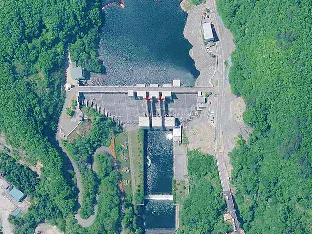
English: Taki Dam (Kuji).
日本語: 滝ダム・滝発電所 (岩手県)。 |
| Date | |
| Source | http://mapps.gsi.go.jp/maplibSearch.do?specificationId=1220712 |
| Author |
Geospatial Information Authority of Japan Retouch: Qurren (talk) |
| Camera location | | View this and other nearby images on: OpenStreetMap |
|---|
.jpg¶ms=040.151468_N_0141.723294_E_globe:Earth_type:camera__&language=en)
Licensing

|
This work is licensed under the Government of Japan Standard Terms of Use (Ver.2.0). The Terms of Use are compatible with the Creative Commons Attribution License 4.0 International. For terms of use this work, see this license page.
|
This file is licensed under the Creative Commons Attribution 4.0 International license.
Attribution: 国土地理院 (Geospatial Information Authority of Japan)
- You are free:
- to share – to copy, distribute and transmit the work
- to remix – to adapt the work
- Under the following conditions:
- attribution – You must give appropriate credit, provide a link to the license, and indicate if changes were made. You may do so in any reasonable manner, but not in any way that suggests the licensor endorses you or your use.
File history
Click on a date/time to view the file as it appeared at that time.
| Date/Time | Thumbnail | Dimensions | User | Comment | |
|---|---|---|---|---|---|
| current | 01:28, 17 June 2018 | | 840 × 630 (191 KB) | Qurren | trim |
| 01:25, 17 June 2018 |  | 849 × 638 (196 KB) | Qurren | {{Information |Description={{en|1=Taki Dam (en:Kuji, Iwate).}} {{ja|1=滝ダム・滝発電所 (岩手県)。}} |Source=http://mapps.gsi.go.jp/maplibSearch.do?specificationId=1220712 |Author=Geospatial Information Authority of Japan<br />Retouch: ~~~ |Date=2011-05-26 |Permission= |other_versions= }} {{Location dec|40.151468|141.723294}} == {{int:license-header}} == {{GJSTU-2.0|terms=http://www.gsi.go.jp/kikakuchousei/kikakuchousei40182.html|attr=国土地理院 (Geospatial Information Authority of Jap... |
File usage
The following pages on the English Wikipedia use this file (pages on other projects are not listed):
Global file usage
The following other wikis use this file:
.jpg)