Size of this preview: 800 × 383 pixels. Other resolutions: 320 × 153 pixels | 640 × 306 pixels | 1,144 × 547 pixels.
Original file (1,144 × 547 pixels, file size: 170 KB, MIME type: image/png)
| This is a file from the Wikimedia Commons. Information from its description page there is shown below. Commons is a freely licensed media file repository. You can help. |
Summary
| Description |
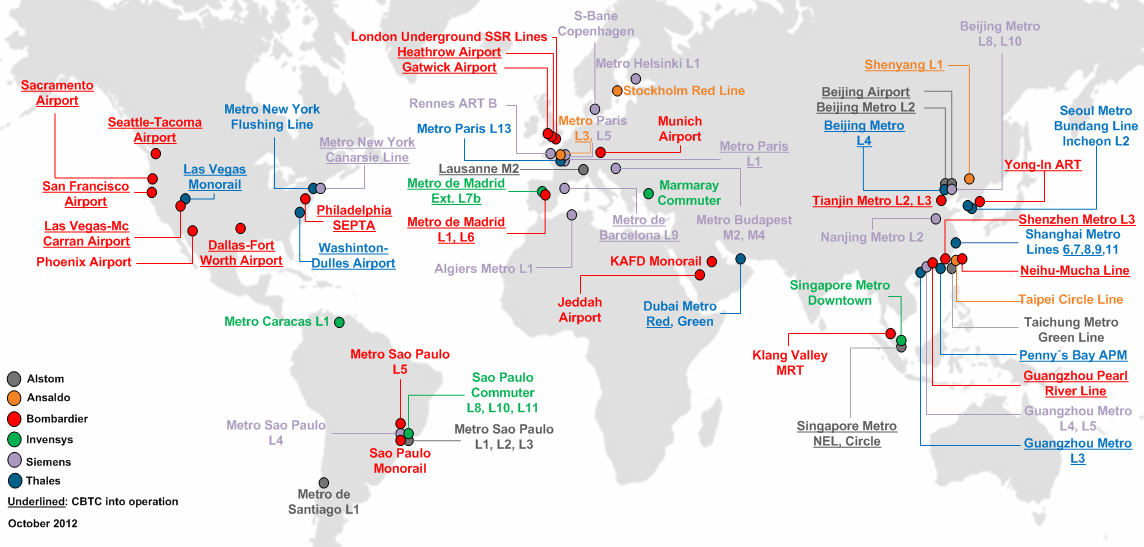
English: Radio-based CBTC projects around the world |
| Date | |
| Source | Own work |
| Author | Israel.abad |
Licensing
I, the copyright holder of this work, hereby publish it under the following license:
This file is licensed under the Creative Commons Attribution-Share Alike 3.0 Unported license.
- You are free:
- to share – to copy, distribute and transmit the work
- to remix – to adapt the work
- Under the following conditions:
- attribution – You must give appropriate credit, provide a link to the license, and indicate if changes were made. You may do so in any reasonable manner, but not in any way that suggests the licensor endorses you or your use.
- share alike – If you remix, transform, or build upon the material, you must distribute your contributions under the same or compatible license as the original.
File history
Click on a date/time to view the file as it appeared at that time.
| Date/Time | Thumbnail | Dimensions | User | Comment | |
|---|---|---|---|---|---|
| current | 15:42, 8 October 2012 | | 1,144 × 547 (170 KB) | Israel.abad | Klang Valley added (Malaysia). Tianjin L3 now into operation Oct2012 |
| 15:54, 9 July 2012 |  | 1,148 × 533 (166 KB) | Israel.abad |
File usage
The following pages on the English Wikipedia use this file (pages on other projects are not listed):
Global file usage
The following other wikis use this file:
- Usage on es.wikipedia.org
- Usage on id.wikipedia.org
- Usage on ja.wikipedia.org
- Usage on nl.wikipedia.org