Size of this preview: 643 × 600 pixels. Other resolutions: 257 × 240 pixels | 515 × 480 pixels | 823 × 768 pixels | 1,098 × 1,024 pixels | 2,196 × 2,048 pixels | 3,507 × 3,271 pixels.
Original file (3,507 × 3,271 pixels, file size: 1.71 MB, MIME type: image/jpeg)
| This is a file from the Wikimedia Commons. Information from its description page there is shown below. Commons is a freely licensed media file repository. You can help. |
Summary
| Description |
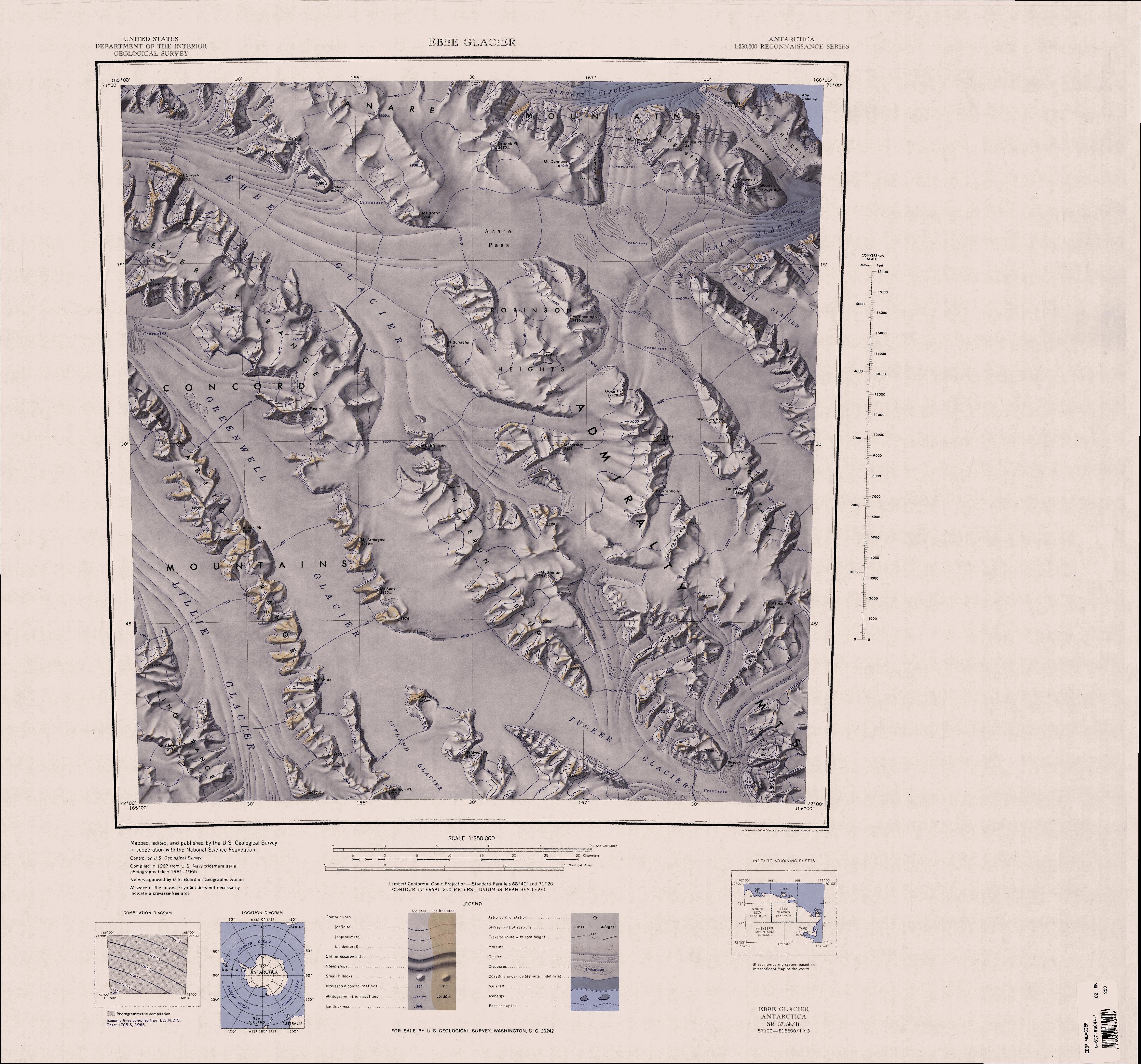
English: 1:250,000-scale topographic reconnaissance map of the Ebbe Glacier area in the Admiralty Range from 165°-168°E to 71°-72°S in Antarctica, including Greenwell, Lillie and Tucker Glacier. Mapped, edited and published by the U.S. Geological Survey in cooperation with the National Science Foundation. |
|||
| Date | ||||
| Source | http://usarc.usgs.gov/drg_dload.shtml | |||
| Author | United States Geological Survey | |||
| Permission (Reusing this file) |
|
File history
Click on a date/time to view the file as it appeared at that time.
| Date/Time | Thumbnail | Dimensions | User | Comment | |
|---|---|---|---|---|---|
| current | 20:31, 3 April 2005 | | 3,507 × 3,271 (1.71 MB) | Achim Raschka | Map of Antarctica by the United States Antarctic Ressource Center of the US Geological Society. {{PD-US}} Copyrights and Trademarks USGS-authored or produced data and information are in the public domain. While the content of most USGS web pages is in th |
File usage
The following pages on the English Wikipedia use this file (pages on other projects are not listed):
- Admiralty Mountains
- Anare Mountains
- Barnett Glacier
- Concord Mountains
- Dennistoun Glacier
- Dunedin Range
- Everett Range
- Findlay Range
- Hedgpeth Heights
- Homerun Range
- King Range (Antarctica)
- Lillie Glacier
- Lyttelton Range
- McGregor Range (Antarctica)
- Mirabito Range
- Quam Heights
- Robinson Heights
- Tucker Glacier
- Victory Mountains
Global file usage
The following other wikis use this file:
- Usage on bg.wikipedia.org
- Usage on ceb.wikipedia.org
- Usage on de.wikipedia.org
- Usage on he.wikipedia.org
- Usage on it.wikipedia.org
- Monti dell'Ammiragliato
- Ghiacciaio Greenwell
- Ghiacciaio Ebbe
- Dorsale Lyttelton
- Dorsale Homerun
- Cime Robinson
- Dorsale Dunedin
- Ghiacciaio Rastorfer
- Montagne della Concordia
- Ghiacciaio Atkinson
- Ghiacciaio Dennistoun
- Ghiacciaio Church
- Ghiacciaio Leander
- Ghiacciaio Cracktrack
- Ghiacciaio Lann
- Ghiacciaio Rowles
- Montagne ANARE
- Ghiacciaio Robertson
- Dorsale Mirabito
- Dorsale Everett
- Dorsale King
- Usage on nn.wikipedia.org
- Usage on no.wikipedia.org
- Usage on pl.wikipedia.org
- Usage on www.wikidata.org
- Usage on zh.wikipedia.org