
Size of this preview: 401 × 599 pixels. Other resolutions: 160 × 240 pixels | 321 × 480 pixels | 514 × 768 pixels | 685 × 1,024 pixels | 1,371 × 2,048 pixels | 2,592 × 3,872 pixels.
Original file (2,592 × 3,872 pixels, file size: 1.73 MB, MIME type: image/jpeg)
| This is a file from the Wikimedia Commons. Information from its description page there is shown below. Commons is a freely licensed media file repository. You can help. |
Summary
| Description |
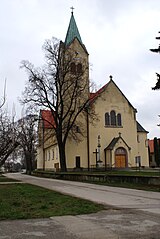
Slovenčina: Cífer (okr. Trnava), Kostol svätého Michala archanjela; celkový pohľad
English: Cífer, Slovakia, Church
Čeština: Cífer kostel |
| Date | |
| Source | Own work |
| Author | feťour |
| Object location | | View this and other nearby images on: OpenStreetMap |
|---|
Licensing
| I, the copyright holder of this work, release this work into the public domain. This applies worldwide. In some countries this may not be legally possible; if so: I grant anyone the right to use this work for any purpose, without any conditions, unless such conditions are required by law. |
File history
Click on a date/time to view the file as it appeared at that time.
| Date/Time | Thumbnail | Dimensions | User | Comment | |
|---|---|---|---|---|---|
| current | 22:27, 28 November 2010 | | 2,592 × 3,872 (1.73 MB) | Feťour | New shot with a clear chip. |
| 16:09, 23 November 2009 |  | 3,872 × 2,592 (897 KB) | Feťour | Category:Cífer | |
| 03:14, 23 November 2009 |  | 3,872 × 2,592 (2.18 MB) | Feťour | {{Information |Description={{en|1=Cífer, Slovakia, Church}} {{cs|1=Cífer kostel}} |Source=own work |Author=feťour |Date=2009-11-22 |Permission= |other_versions= }} Category:Cífer |
File usage
The following pages on the English Wikipedia use this file (pages on other projects are not listed):
Global file usage
The following other wikis use this file:
- Usage on bg.wikipedia.org
- Usage on ca.wikipedia.org
- Usage on cs.wikipedia.org
- Usage on eo.wikipedia.org
- Usage on es.wikipedia.org
- Usage on eu.wikipedia.org
- Usage on fr.wikipedia.org
- Usage on hu.wikipedia.org
- Usage on pl.wikipedia.org
- Usage on pt.wikipedia.org
- Usage on ro.wikipedia.org
- Usage on ru.wikipedia.org
- Usage on sk.wikipedia.org
- Usage on sr.wikipedia.org
- Usage on uk.wikipedia.org
- Usage on www.wikidata.org