File:Burnt Quarter, State Route 613 vicinity, Dinwiddie vicinity (Dinwiddie County, Virginia).jpg

Size of this preview: 800 × 474 pixels. Other resolutions: 320 × 190 pixels | 640 × 379 pixels | 930 × 551 pixels.
Original file (930 × 551 pixels, file size: 174 KB, MIME type: image/jpeg)
| This is a file from the Wikimedia Commons. Information from its description page there is shown below. Commons is a freely licensed media file repository. You can help. |
|
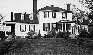
This is an image of a place or building that is listed on the National Register of Historic Places in the United States of America. Its reference number is 69000235. |
| Description |
English: Burnt Quarter, State Route 613 vicinity, Dinwiddie vicinity (Dinwiddie County, Virginia)
cropped
|
|||||
| Date | Unknown date | |||||
| Source | http://memory.loc.gov/pnp/habshaer/va/va0300/va0340/photos/161090pv.jpg | |||||
| Author | Unknown author |

.jpg)
.jpg&action=edit&redlink=1)
.jpg)
| Object location | | View this and other nearby images on: OpenStreetMap |
|---|
.jpg¶ms=037.138611_N_-077.625000_E_globe:Earth_class:object_region:US_type:landmark_scale:1500_&language=en)
File history
Click on a date/time to view the file as it appeared at that time.
| Date/Time | Thumbnail | Dimensions | User | Comment | |
|---|---|---|---|---|---|
| current | 21:18, 13 December 2010 | | 930 × 551 (174 KB) | KudzuVine | {{Information |Description={{en|1=Burnt Quarter, State Route 613 vicinity, Dinwiddie vicinity (Dinwiddie County, Virginia) cropped {{PD-USGov-Interior-HABS|VA,27-____,2-1}} }} |Source=http://memory.loc.gov/pnp/habshaer/va/va0300/va0340/photos/161090pv.jpg |
File usage
The following pages on the English Wikipedia use this file (pages on other projects are not listed):
Global file usage
The following other wikis use this file:
- Usage on www.wikidata.org
.jpg)