Size of this preview: 800 × 534 pixels. Other resolutions: 320 × 213 pixels | 640 × 427 pixels | 1,102 × 735 pixels.
Original file (1,102 × 735 pixels, file size: 970 KB, MIME type: image/jpeg)
| This is a file from the Wikimedia Commons. Information from its description page there is shown below. Commons is a freely licensed media file repository. You can help. |
Summary
| Description |
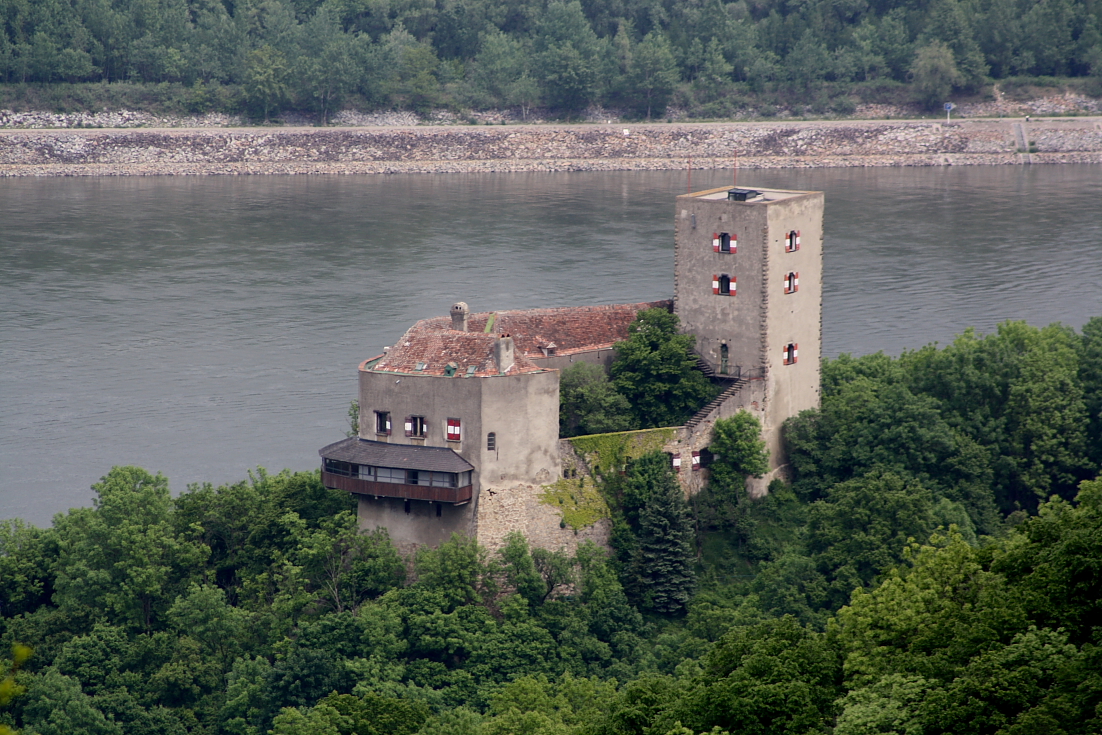
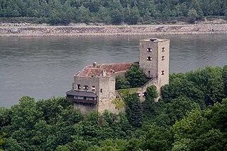
Deutsch: Blick von der Tempelbergwarte auf die Burg Greifenstein (Südwestansicht) und im Hintergrund die Donau.
Die im Kern romanische Burg befindet sich nordöstlich von Wien und am nördlichsten Punkt der Alpen, dem „Hangintenstein“ (hängender Stein). Der Name „Hangintenstein“ wurde schon um 900 urkundlich erwähnt und 955 wird das Land bis zu diesem Felsen vom Bayernherzog an das Bistum Passau übergeben. Ihr heutiges Aussehen geht auf die Renovierungen durch Fürst Johann I. von Liechtenstein zu Anfang des 19. Jahrhunderts zurück. Struktur und Charakter der hochmittelalterlichen Anlage blieben dabei erhalten: [1]. Nach einem Kabelbrand im Jahr 2006 wurde die Burg geschlossen: [2]. 2017 kaufte der Unternehmer und Kunstmäzen Ernst C. Strobl die Burg um rd. 2,5 Mio. Euro: [3] und setzte sie wieder instand bzw. ist dabei (Stand: 2021). |
| Date | |
| Source | Own work |
| Author | C.Stadler/Bwag |
| Permission (Reusing this file) |
Deutsch: Hallo, du darfst mein Foto kostenlos nutzen, aber nenne mich bitte als Fotograf, beispielsweise „Foto: C.Stadler/Bwag“ oder © C.Stadler/Bwag; CC-BY-SA-4.0. Auf mehr Angaben bestehe ich nicht - im Gegensatz zu manch anderen, die die Vorgaben der unten angeführten Lizenzierung auf Punkt und Beistrich einfordern. English: Feel free to use my photos, but please mention me as the author like © C.Stadler/Bwag or © C.Stadler/Bwag; CC-BY-SA-4.0 (that's good enough) and if you want send me a message: bwag@gmx.net. |
| Other versions |
|
_-_Burg_(b).JPG)
| Camera location | | View this and other nearby images on: OpenStreetMap |
|---|
| Object location | | View this and other nearby images on: OpenStreetMap |
|---|
Licensing
I, the copyright holder of this work, hereby publish it under the following license:
This file is licensed under the Creative Commons Attribution-Share Alike 3.0 Unported license.
- You are free:
- to share – to copy, distribute and transmit the work
- to remix – to adapt the work
- Under the following conditions:
- attribution – You must give appropriate credit, provide a link to the license, and indicate if changes were made. You may do so in any reasonable manner, but not in any way that suggests the licensor endorses you or your use.
- share alike – If you remix, transform, or build upon the material, you must distribute your contributions under the same or compatible license as the original.
File history
Click on a date/time to view the file as it appeared at that time.
| Date/Time | Thumbnail | Dimensions | User | Comment | |
|---|---|---|---|---|---|
| current | 17:40, 13 May 2010 | | 1,102 × 735 (970 KB) | Bwag | {{Information |Description={{de|1=de:Burg Greifenstein, Südwestansicht (von der Tempelbergwarte). Im Hintergrund die Donau |Source={{own}} |Author=Bwag |Date=2010-05-13 |Permission= |other_versions= }} [[Category:Burg Greifenstein (Ni |
File usage
The following pages on the English Wikipedia use this file (pages on other projects are not listed):
Global file usage
The following other wikis use this file:
- Usage on ceb.wikipedia.org
- Usage on cs.wikipedia.org
- Usage on de.wikipedia.org
- Usage on id.wikipedia.org
- Usage on ru.wikipedia.org
- Usage on sv.wikipedia.org
- Usage on uk.wikipedia.org
- Usage on www.wikidata.org