No higher resolution available.
BraerStorm1993.png (352 × 232 pixels, file size: 73 KB, MIME type: image/png)
| This is a file from the Wikimedia Commons. Information from its description page there is shown below. Commons is a freely licensed media file repository. You can help. |
Summary
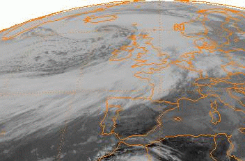
| Description |
English: This is a Meteosat infrared satellite image of the Braer Storm of January 10, 1993, while at peak intensity. This storm is the strongest known extratropical cyclone to exist across the northern Atlantic ocean. |
| Source | http://www.ncdc.noaa.gov/gibbs/image/MET-4/IR/1993-01-10-12 |
| Author | National Climatic Data Center |
Licensing
This image is in the public domain because it contains materials that originally came from the U.S. National Oceanic and Atmospheric Administration, taken or made as part of an employee's official duties.
|
Original upload log
| Date/Time | Dimensions | User | Comment |
|---|---|---|---|
| 13 April 2010, 22:01:14 | 352 × 232 (54844 bytes) | Thegreatdr (talk · contribs) | {{Information |Description={{en|1=This is a Meteosat infrared satellite image of the Braer Storm of January 10, 1993, while at peak intensity. This storm is the strongest known extratropical cyclone to exist across the northern Atlantic ocean.}} |Source= |
File history
Click on a date/time to view the file as it appeared at that time.
| Date/Time | Thumbnail | Dimensions | User | Comment | |
|---|---|---|---|---|---|
| current | 05:47, 25 August 2014 | | 352 × 232 (73 KB) | GifTagger | Bot: Converting file to superior PNG file. (Source: BraerStorm1993.gif). This GIF was problematic due to non-greyscale color table. |
File usage
The following pages on the English Wikipedia use this file (pages on other projects are not listed):
Global file usage
The following other wikis use this file:
- Usage on ar.wikipedia.org
- Usage on ca.wikipedia.org
- Usage on el.wikipedia.org
- Usage on et.wikipedia.org
- Usage on fa.wikipedia.org
- Usage on it.wikipedia.org
- Usage on nl.wikipedia.org
- Usage on sr.wikipedia.org
- Usage on vi.wikipedia.org
- Usage on www.wikidata.org
- Usage on zh.wikipedia.org