
Size of this PNG preview of this SVG file: 736 × 600 pixels. Other resolutions: 295 × 240 pixels | 589 × 480 pixels | 942 × 768 pixels | 1,257 × 1,024 pixels | 2,513 × 2,048 pixels.
Original file (SVG file, nominally 800 × 652 pixels, file size: 21 KB)
| This is a file from the Wikimedia Commons. Information from its description page there is shown below. Commons is a freely licensed media file repository. You can help. |
Summary
| Description |
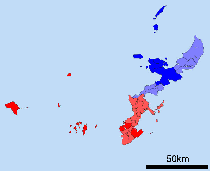
English: A map of the Okinawan Islands displaying the distribution of the Northern Okinawan Language (Kunigami) in blue, and the South-Central Okinawan Language (Shuri-Naha) in red. The darker areas represent regions that have been officially classified by the following sources:
|
| Date | (UTC) |
| Source | Map_of_Okinawa_Prefecture_Ja.svg |
| Author |
|
| This is a retouched picture, which means that it has been digitally altered from its original version. Modifications: Removed the Daito, Yaeyama, Miyako and Yonaguni islands. Changed all the links to point towards their English Wikipedia counterparts. Changed the colours on the map to demonstrate the Okinawan language boundaries.. The original can be viewed here: Map of Okinawa Prefecture Ja.svg:
|
Licensing
I, the copyright holder of this work, hereby publish it under the following licenses:
| This file is licensed under the Creative Commons Attribution-Share Alike 3.0 Unported license. | ||
| ||
| This licensing tag was added to this file as part of the GFDL licensing update. |

|
Permission is granted to copy, distribute and/or modify this document under the terms of the GNU Free Documentation License, Version 1.2 or any later version published by the Free Software Foundation; with no Invariant Sections, no Front-Cover Texts, and no Back-Cover Texts. A copy of the license is included in the section entitled GNU Free Documentation License. |
You may select the license of your choice.
Original upload log
This image is a derivative work of the following images:
- File:Map_of_Okinawa_Prefecture_Ja.svg licensed with Cc-by-sa-3.0-migrated, GFDL
- 2008-04-30T00:12:31Z Krisgrotius 800x652 (14670 Bytes) {{Information| |Description= Map of Okinawa Prefecture, Japan. |Source= Japanese wiki [http://ja.wikipedia.org/wiki/%E7%94%BB%E5%83%8F:%E5%8C%85%E6%8B%AC%E8%87%AA%E6%B2%BB%E4%BD%93%E5%8C%BA%E7%94%BB%E5%9B%B3_47000.svg] |Da
Uploaded with derivativeFX
File history
Click on a date/time to view the file as it appeared at that time.
| Date/Time | Thumbnail | Dimensions | User | Comment | |
|---|---|---|---|---|---|
| current | 00:49, 25 December 2010 | | 800 × 652 (21 KB) | Io Katai | fixed links |
| 00:47, 25 December 2010 |  | 800 × 652 (21 KB) | Io Katai | Missed out on a few links | |
| 00:41, 25 December 2010 |  | 800 × 652 (21 KB) | Io Katai | {{Information |Description=A map of the Okinawan Islands displaying the distribution of the Northern Okinawan Language (Kunigami) in blue, and the South-Central Okinawan Language (Shuri-Naha) in red. The darker areas represent regions that have been offic |
File usage
The following pages on the English Wikipedia use this file (pages on other projects are not listed):
Global file usage
The following other wikis use this file:
- Usage on ca.wikipedia.org
- Usage on cdo.wikipedia.org
- Usage on cs.wikipedia.org
- Usage on et.wikipedia.org
- Usage on fa.wikipedia.org
- Usage on fi.wikipedia.org
- Usage on gd.wikipedia.org
- Usage on gl.wikipedia.org
- Usage on gn.wikipedia.org
- Usage on haw.wikipedia.org
- Usage on hu.wikipedia.org
- Usage on id.wikipedia.org
- Usage on incubator.wikimedia.org
- Usage on it.wikipedia.org
- Usage on ja.wikipedia.org
- Usage on ko.wikipedia.org
- Usage on ms.wikipedia.org
- Usage on pt.wikipedia.org
- Usage on ru.wikipedia.org
- Usage on sc.wikipedia.org
- Usage on simple.wikipedia.org
- Usage on sr.wikipedia.org
- Usage on sv.wikipedia.org
- Usage on th.wikipedia.org
- Usage on tr.wikipedia.org
- Usage on uk.wikipedia.org
- Usage on vi.wikipedia.org
- Usage on zh-min-nan.wikipedia.org
- Usage on zh.wikipedia.org