No higher resolution available.
Billings_Metropolitan_Area.png (539 × 313 pixels, file size: 24 KB, MIME type: image/png)
| This is a file from the Wikimedia Commons. Information from its description page there is shown below. Commons is a freely licensed media file repository. You can help. |
| Description |
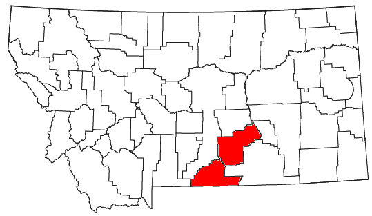
English: Locator map of the Billings Metropolitan Statistical Area in the southern part of the U.S. state of Montana. |
||
| Date | |||
| Source | Modified from this United States Census Bureau file, based on this Census definitions list. | ||
| Author | Nyttend | ||
| Permission (Reusing this file) |
US Government work is public domain, and my work is
|
File history
Click on a date/time to view the file as it appeared at that time.
| Date/Time | Thumbnail | Dimensions | User | Comment | |
|---|---|---|---|---|---|
| current | 03:08, 18 April 2011 | | 539 × 313 (24 KB) | Nyttend | See the second link in the "source" line: it's just two counties, not seven |
| 02:51, 18 April 2011 |  | 539 × 313 (24 KB) | Wolfdog406 | Added two more counties. | |
| 01:46, 18 April 2011 |  | 539 × 313 (24 KB) | Wolfdog406 | Added more counties to the Billings Metro Area. | |
| 03:35, 27 July 2008 |  | 539 × 313 (24 KB) | Nyttend | {{Information |Description=Locator map of the {{w|Billings Metropolitan Area|Billings Metropolitan Statistical Area}} in the southern part of the {{w|U.S. state}} of {{w|Montana}}. |Source=Modified from [http://www2.census.gov/geo/maps/general_ref/cousub_ |
File usage
No pages on the English Wikipedia use this file (pages on other projects are not listed).
Global file usage
The following other wikis use this file:
- Usage on es.wikipedia.org