No higher resolution available.
Benin_Empire_sphere_of_influence.PNG (270 × 221 pixels, file size: 10 KB, MIME type: image/png)
| This is a file from the Wikimedia Commons. Information from its description page there is shown below. Commons is a freely licensed media file repository. You can help. |
| Description |
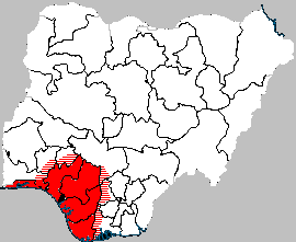
English: Map showing the sphere of influence of the historical Empire of Benin in modern-day Nigeria
Italiano: Sfera di influenza dell'Impero del Benin nella attuale Nigeria |
| Date | (UTC) |
| Source | |
| Author |
|
| This is a retouched picture, which means that it has been digitally altered from its original version. Modifications: some states colored. The original can be viewed here: Delta State Nigeria.png:
|
This file is licensed under the Creative Commons Attribution-Share Alike 3.0 Unported license.
- You are free:
- to share – to copy, distribute and transmit the work
- to remix – to adapt the work
- Under the following conditions:
- attribution – You must give appropriate credit, provide a link to the license, and indicate if changes were made. You may do so in any reasonable manner, but not in any way that suggests the licensor endorses you or your use.
- share alike – If you remix, transform, or build upon the material, you must distribute your contributions under the same or compatible license as the original.
Original upload log
This image is a derivative work of the following images:
- File:Delta_State_Nigeria.png licensed with Cc-by-sa-3.0-migrated, GFDL
- 2005-04-17T12:49:50Z Jaimz height-field 270x221 (19056 Bytes) en:Map showing location of Delta state in Nigeria {{fr|1=Carte montrant la position de l'état de Delta au Nigeria Drawn by/dessiné par [[User:Jaimz height-field|Jaimz height-field]] {{GFDL}} [[Category:Maps of Nigeria]] }}
Uploaded with derivativeFX
File history
Click on a date/time to view the file as it appeared at that time.
| Date/Time | Thumbnail | Dimensions | User | Comment | |
|---|---|---|---|---|---|
| current | 16:56, 5 April 2010 | | 270 × 221 (10 KB) | Doctor Dodge | {{Information |Description=en:Map showing the sphere of influence of the historical Empire of Benin in modern-day Nigeria it:Sfera di influenza dell'Impero del Benin nella attuale Nigeria |Source=*File:Delta_State_Nigeria.png |Date=2010-04-05 16:52 |
File usage
The following pages on the English Wikipedia use this file (pages on other projects are not listed):
Global file usage
The following other wikis use this file:
- Usage on ca.wikipedia.org
- Usage on es.wikipedia.org
- Usage on fr.wikipedia.org
- Usage on uk.wikipedia.org